|
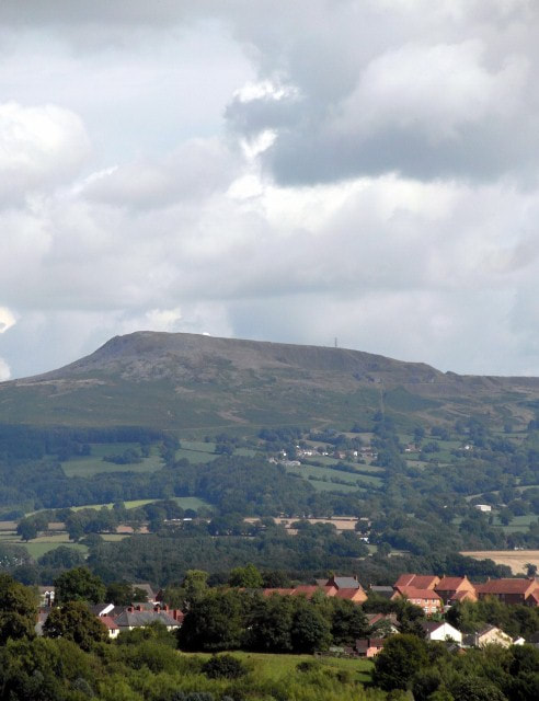
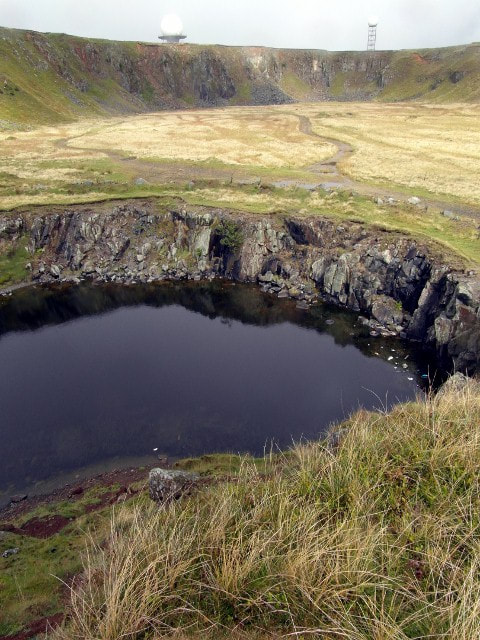
A very unusual excursion into England, and a trip in the time machine back to 2013... 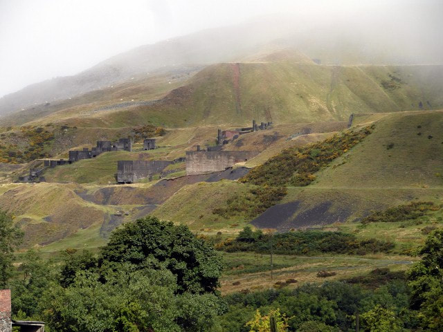 In Ludlow with a few hours to kill before meeting a customer, I was idly studying an OS map when my eye caught the name "Clee Hill". It was only six miles away and by the looks of things, had a quarry. We fired up the car and high-tailed it up to the village of Clee. After the Georgian gentility of Ludlow, this place seemed like a Kentucky mining village. It has what must be the unfriendliest village shop in Shropshire; but I liked it. A pub called "The Kremlin" was also noted, surely a story there. Provisions purchased, we headed up by the sign marked "Dhustone". From the Welsh name for Dolerite, apparently, although the locals called it "Jewstone". Much has been written about the railways hereabouts, and I won't labour the point; there are other places on the web for that. I'll give some links at the foot for those who want to browse further. We rolled up the steep road, noting what looked like a ruined incline beside some lovely brick houses with fantastical chimneys, built by the quarry company for it's workers. One rejoiced in the name "Hedgehog Cottage". 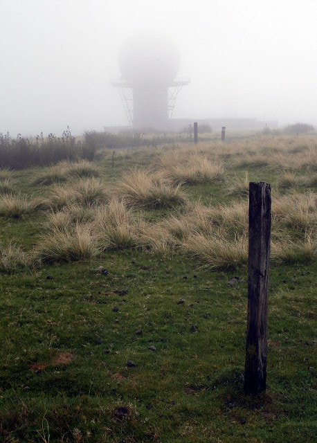 The weather wasn't promising at all, but as we reached a plateau, the bulk of Titterstone Clee loomed from the mist. It's not high by Welsh standards but it's imposing. 533 metres, and the third highest in Shropshire. From this distance it seemed more like a gigantic spoil tip, but I could make out the remains of rock bins and the concrete standings for machinery. We parked up and walked about, heading for a water filled hole. Rounding the corner of a spoil tip I had a sudden stab of alarm. Slowly revealing itself from the mist was an enormous white golf ball on the skyline, like something from a 1960's Dr Who episode. I checked, none were filmed here, although they should have been. I felt the scene needed a Cyberman coming towards me and imagined the Brigadier screeching to a halt in his Mk 1 Land Rover nearby. It was only a strangely disoriented gull, unfortunately, but it didn't spoil the magic. 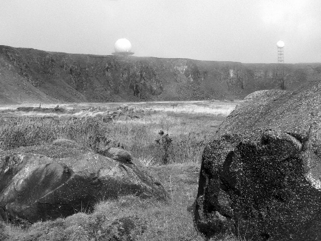 The golf balls; the larger one is part of a National Air Traffic Control radar network, it's little brother being a Met Office weather radar . There are also the remains of an RAF radar station here, too, mainly bits of concrete in the grass. A bronze age hillfort completes this embarrassment of riches, although I failed to note any evidence of ancient activity- but my eye was concentrating on the quarry remains. 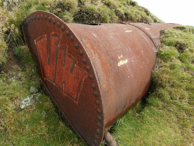 A pressure vessel with graffiti. We noticed graffiti everywhere with the motif "RIP Mitch". I wondered if someone locally had died here, but later found that it referred to Mitch Lucker, frontman and vocalist of a California Death Metal band called Suicide Silence. Their music is typical of the genre, but interesting...so the artist was a fan, I guess. As normally happens when we explore places, I charged about excitedly like a Jack russell terrier scenting rat and ran up to the summit. Petra more sensibly decided to mooch about near the stone crushers and crafted some fine images. All too soon, it was time to leave, as the mist came down to veil the hill again. Later in the afternoon, listening to my customer, I couldn't help but notice the hill in the distance, with it's two strange white shapes atop the crest. I couldn't help wishing I was back up there. It was a fascinating explore and one worthy of another expedition. 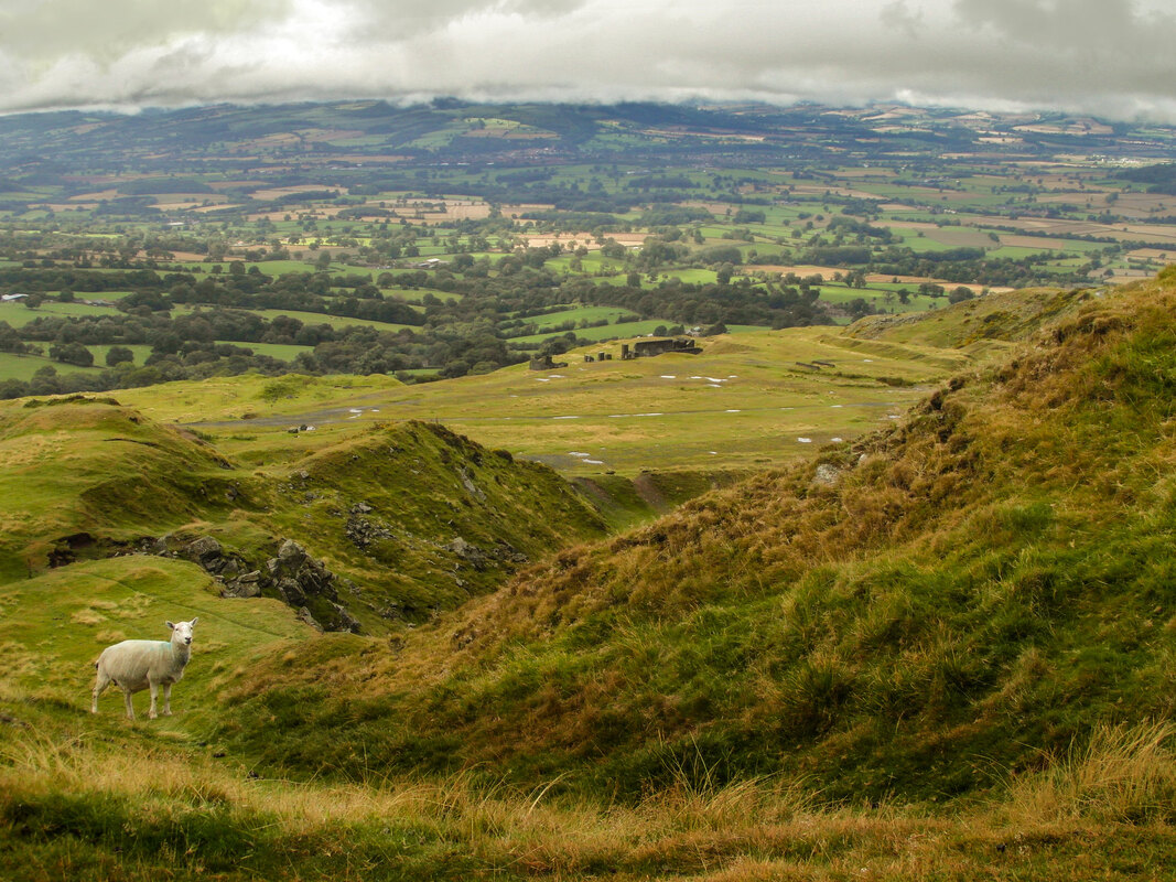 Looking towards Wales from the top workings. Links and interesting facts: I found a site while browsing for information which has some fascinating photographs of the quarry from 1955, with many other interesting details, called "Photos by D J Norton". Recommended. Factoids courtesy of the Industrial Railway Society: " The quarries date from 1858 when a railway was being constructed from Ludlow for the transport of coal. A quarry, opened to produce ballast for the Ludlow & Clee Hill Railway (opened on 24th August 1864), produced such good stone that the industry has flourished there ever since. Three main quarries have operated over the years and in one of these a 3ft 0in gauge rail system was introduced with horse haulage, going over to steam about 1910 when a second-hand loco was obtained. This 0−4−0 saddle tank (Bagnall 1717 of 1903) came to Titterstone Clee from H. Arnold & Sons Ltd, contractors for Embsay Reservoir, Skipton, on which job it was named MARY. It is assumed the loco proved to be superior to the horses, as a few years later a new 0−4−0 side tank was purchased from Avonside (1666 of 1913) and put to work carrying the name TITTERSTONE. This loco was followed by a new Sentinel 4−wheel geared-drive shunter (6222 of 1926) which was named LILIAN. Wagons were pushed by hand along tracks from the quarry face to a collecting point in the middle of the quarry known as "the turnout", from where they were hauled by locomotive to the crusher. From the crusher a mile long incline, which included a three rail section, ran down the side of the hill to an interchange point at Bitterley on the standard gauge line. Although the rail system was closed in 1952, the quarry remained in use until 1962, the stone being conveyed in road vehicles." There is a widely held belief in the local area that the Clee Hills are the highest land eastwards until the Ural Mountains in Russia. Hence the name of the pub in Clee Hill village - The Kremlin Inn. It has even been known for radios in the area to pick up signals via the air traffic control masts from Radio Moscow. The Clee hills are mentioned in A.E.Housman's poem "From Clee to heaven the beacon burns", which is a section of A Shropshire Lad.
|
TracksReceive the occasional Treasure Maps Newsletter- and alerts when a new post is available!
If you enjoy my content, please buy me a coffee!
Check out my other online activity...
Index
All
|
 RSS Feed