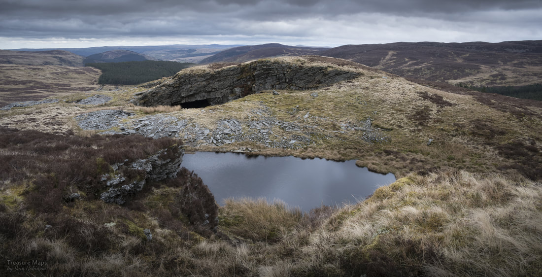
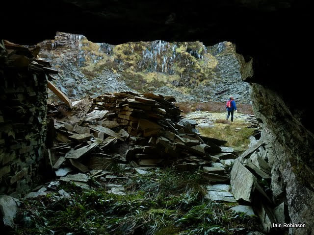
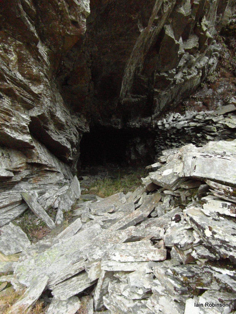
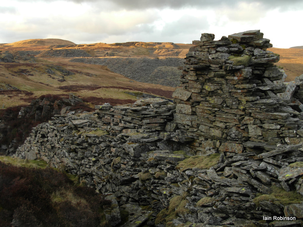
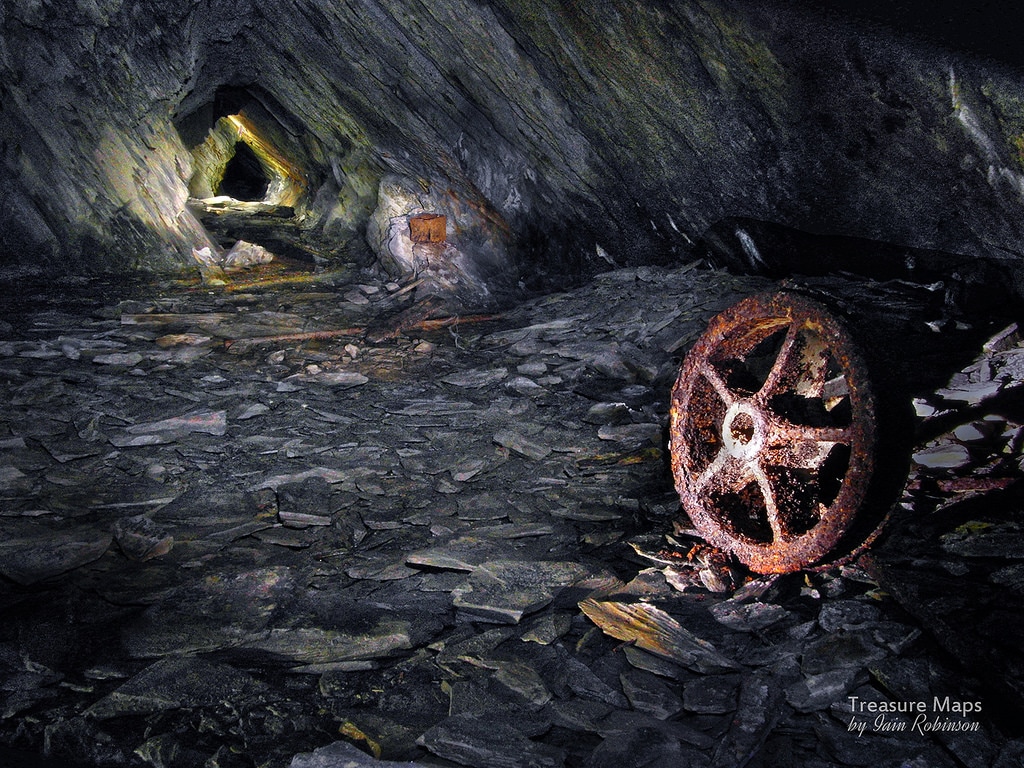
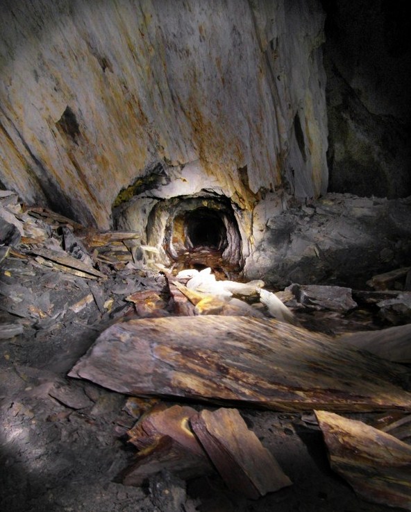
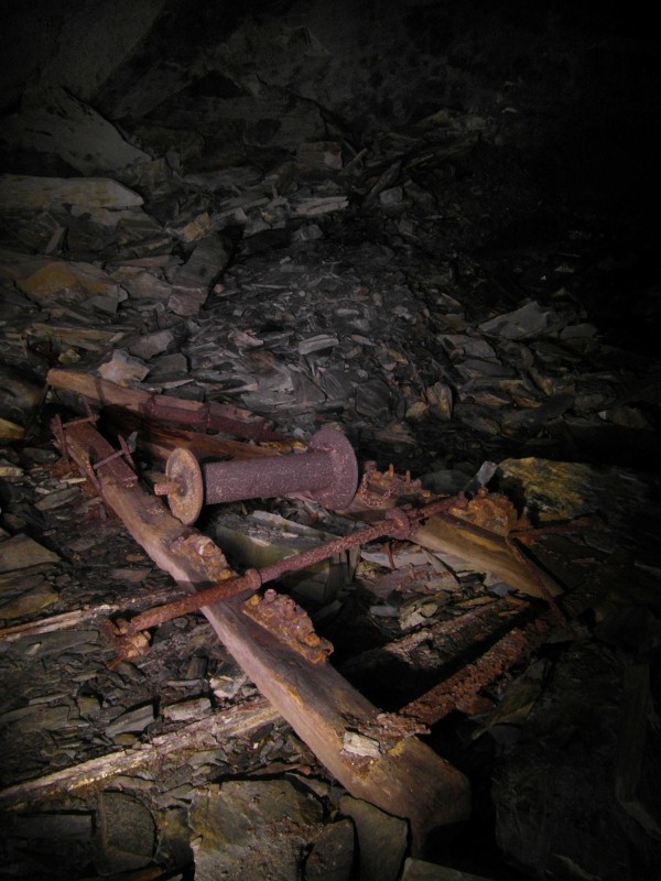
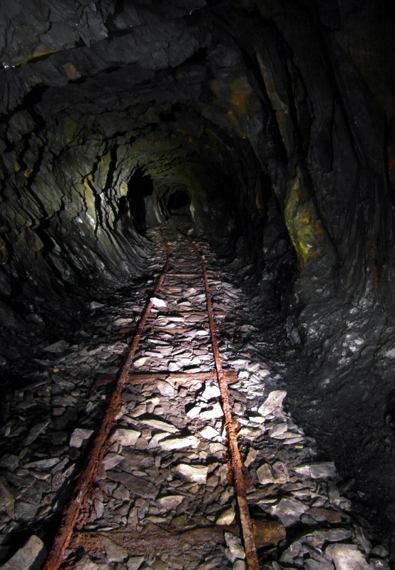
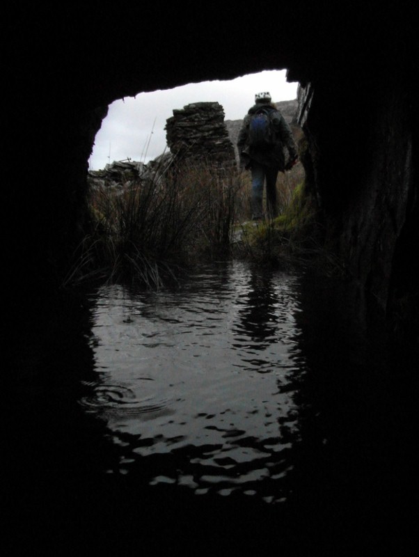
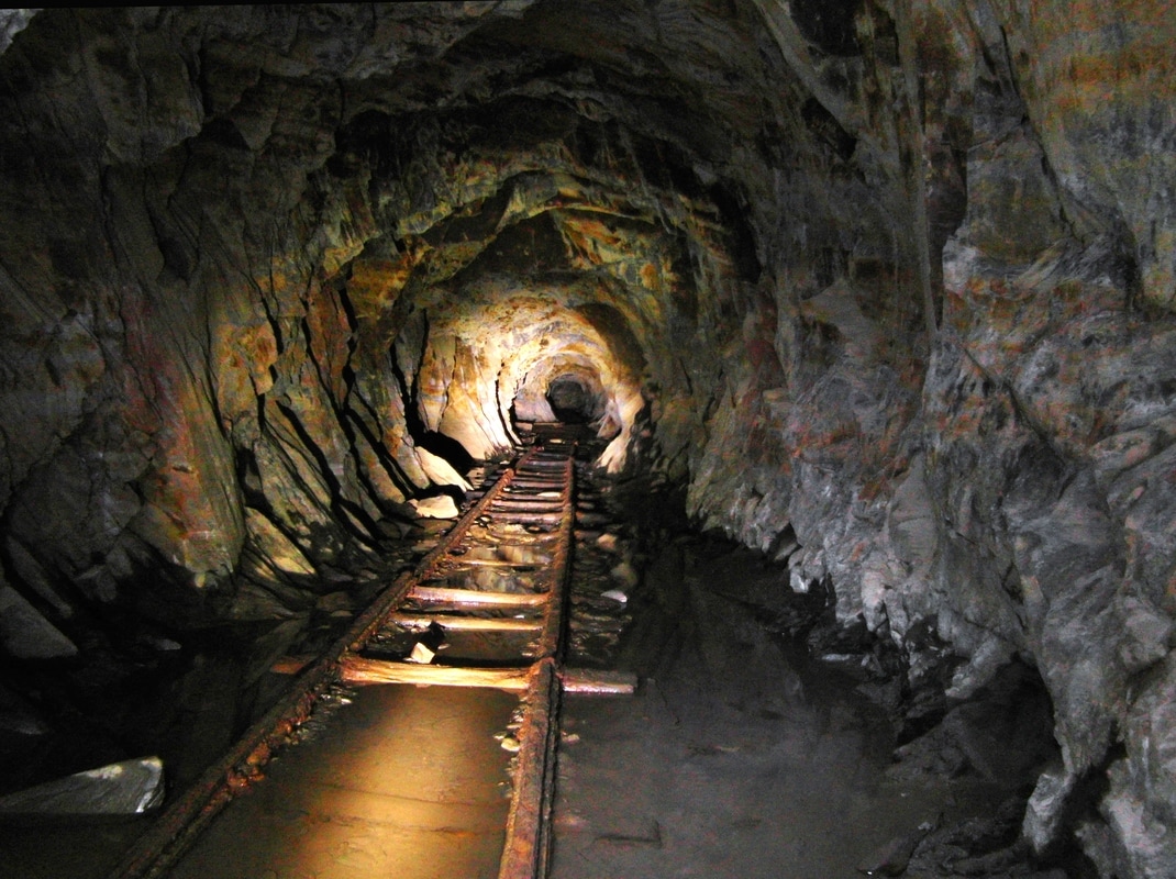
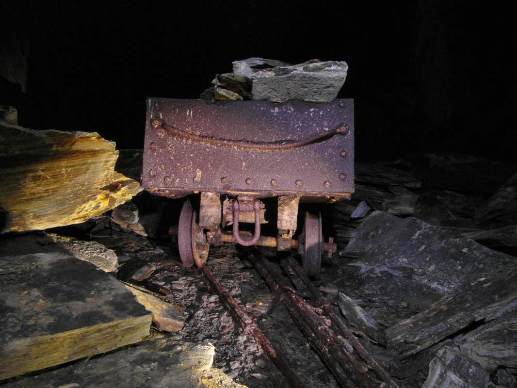
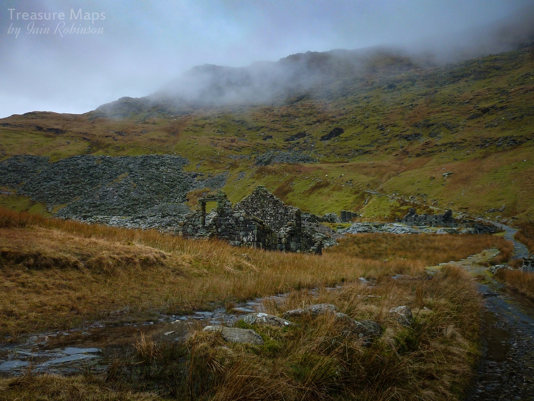
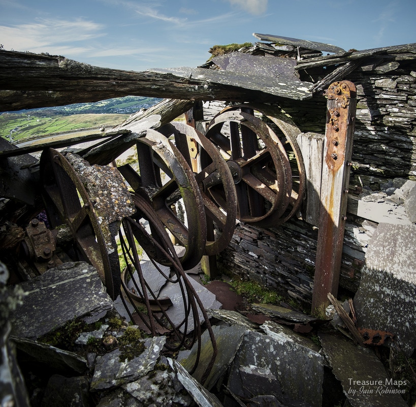
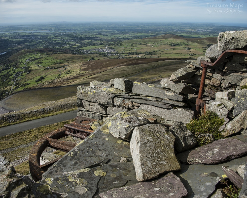
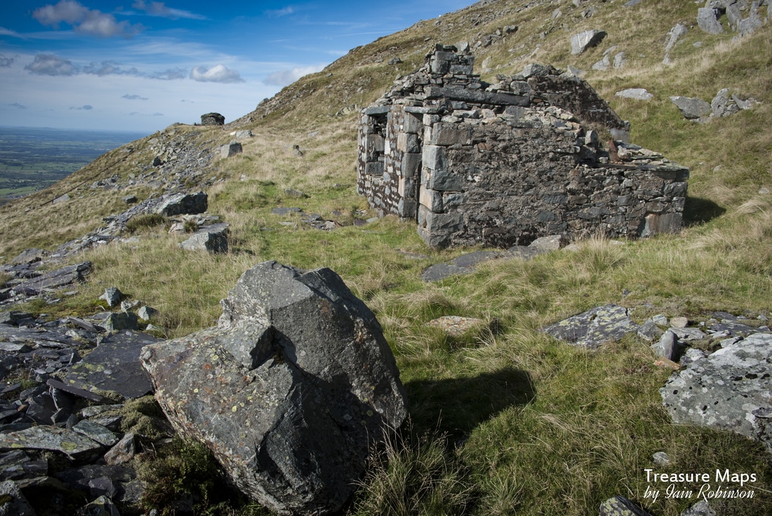
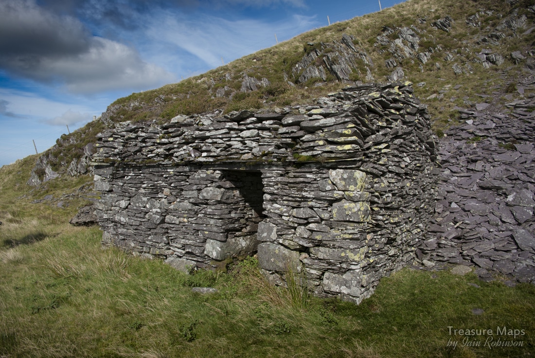
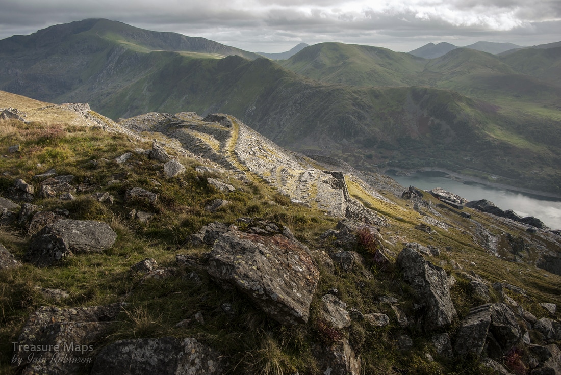
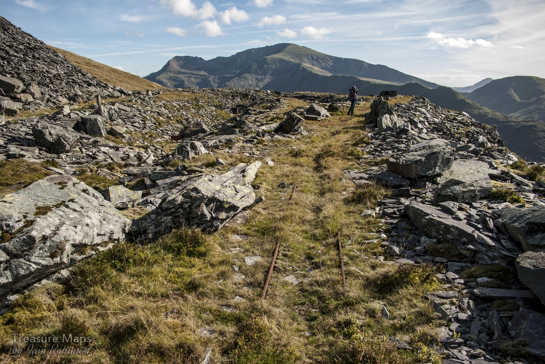
 The drumlin with the excavation of Gatty's twll, taken from the west, looking towards Rhiwbach, which is half a mile behind and below. A fresh look at Fridd and Blaen-y-Cwm quarries It had been almost a year since I had walked along the Rhiwbach tramway. It's not far from where I live, and sometimes that familiarity can make you blasé. Silly, really, because how many folk have somewhere like this on their doorstep? The badlands, as I fondly call them, are a wide stretch of moors to the north and east of Manod Mawr, bounded by Moel Penamnen to the north, by Penmachno and the fine rampart of the Gamallt to the East. Cwm Teigl rises to the challenge in the south and takes on the air of a western movie set, as it gains height towards the bwlch. It changes from mild farmland to desperate country, pock-marked and blasted by huge boulders and ancient mines. It's a rough, damp moor, but far from featureless. There are at least five or six disused quarries and a significant quantity of industrial archaeology, enough to satisfy most people's desire for curiosities. I've written about this area before, and there are numerous sources for further information- which I will list at the end, for those wanting a deeper picture. Here, I would like to make some observations that are a little off the mainstream, but will, I hope, intrigue those who would like to sense the atmosphere of the place. 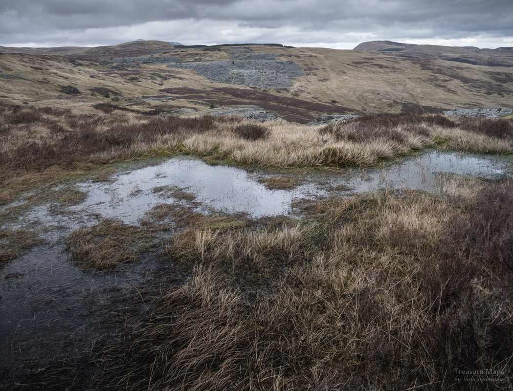 Looking north to Cwt-y-Bugail from Fridd. In the middle ground are the workings of Blaen-y-Cwm. As I stepped out on to the trackbed of the Rhiwbach tramway I immediately felt a sense of well-being wash over me. Even though I was cold, struggling with my camera strap, my rucksac straps and my anorak hood...it felt good. The view beneath Cwm Teigl and across to the Arenigs was magnificent, slightly alloyed by a couple of insensitively placed electric posts, but I wasn't going to let those spoil things...there's always Photoshop for those situations. One of the attractive things about the tramway is that it is level, although very damp, resembling a canal at times. However, the first stretch towards the ancient workings of Fridd is reasonably dry. I stood by the lip of the twll, wondering how long it would be before the tramway formation fell in to the pit . Things are rather intimate between the two of them at this point. A buzzard flew overhead and my thoughts, inspired by the bird's freedom, turned to ideas of going cross-country. Retracing my steps away from the edge of the twll, I wandered onto the beautiful ochre coloured grass, vegetation that looks dry, but is often deeply rent by wet fissures in the ground. There were plenty of "Pylliau", shallow puddles in moss. The way the Welsh pronounce it sounds like footsteps in water. 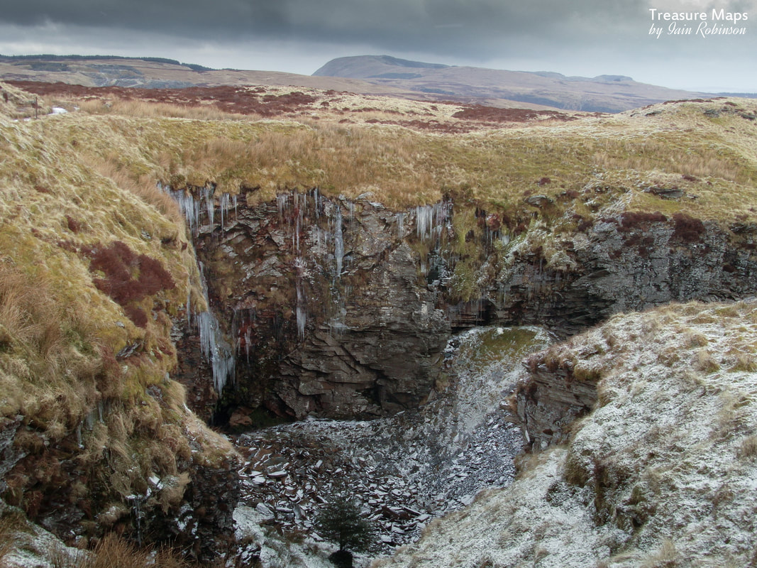 The Fridd pit in winter, by the Rhiwbach tramway, which runs to the left here. The low adit can just be seen at the bottom of the pit. The reason I had decided to strike off the tramway was that I fancied a closer look at Fridd, the earliest workings on the badlands, probably dating from before 1818. Fridd was amalgamated into the Blaen-y-Cwm operation fairly early, but I always think of this part of the excavations as being a distinct entity . As you walk the tramway and go through the cattle grid, the workings and some low, ruined and mysterious structures are off to the right- or east at this point. You come first to the opencut that once led into the Fridd pit. Looking at the place from below the tramway it seems ever more delicate. Water ran in a score of small waterfalls from above into the base of the twll and seeped away into an adit, low in the north wall. There have been many falls in this place and I wouldn't dream of exploring the adit, tempting as it looked. At one time, the tunnel led to the slate mill at Blaen y Cwm, a little further along the tramway to the north. 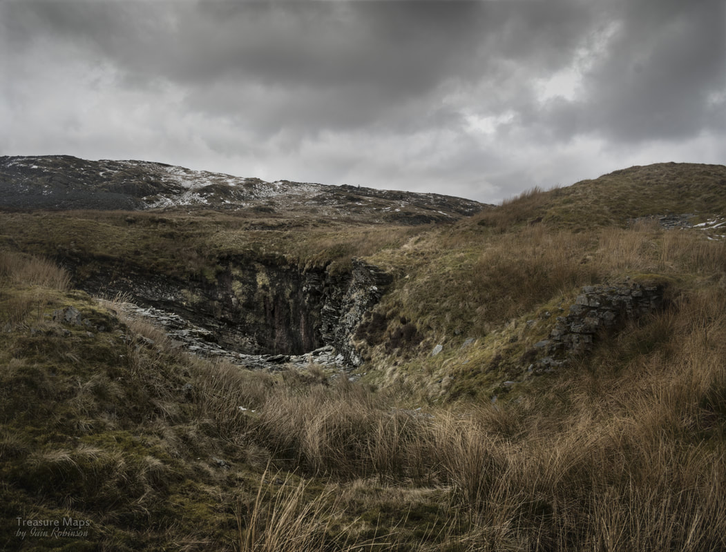 Looking towards Fridd twll from the opencut. Manod Mawr rises in the background. The opencut is, these days, little more than a long depression in the moor, betrayed by a slight change in vegetation. It's much higher than the base of the pit, which must have been dug vigorously lower. Off the tramway and away from the sound of the modern quarry machinery from Manod, there was a sense of glorious isolation. The badlands stretched away from me in all directions- on a weekday you can be pretty sure of not meeting another soul here. I walked on towards another pit, this the earliest one. I've called it Gatty's pit, after Dr W. H. Gatty, the lessee here in 1869-74. He presided over the most significant working of this area. It's a curious place now, seeming so incongruous on the moor. A hole with a huge alcove, like a giant's fireplace, backed by a small drumlin. There's a modest llyn here and a corresponding drumlin, hacked away on one side, a little further on. I stood and took in the scene, chewing over in my mind what I had read about the place. 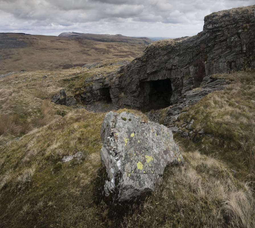 Gatty's twll...it seems that the farthest tunnel once drove under the Rhiwbach Tramway, which passes behind the fencepost here. The other opening is a chamber which has been blocked, once it was much larger. Then, there was one of those light bulb moments that occur sometimes, when you least expect. I realised that the two drumlins had once been one, and the slate between them had been quarried away. I read something about there being a substantial rock formation here at one time- could this be the remains of it? The only fly in the ointment was that, although a tramway from here once ran under the Rhiwbach Tramway to tips on Blaen y Cwm territory, there wasn't enough spoil for such an excavation... As I stood at the impressive head of the Rhiwbach incline*, finally, my thoughts caught up. Perhaps the spoil from the drumlins at the early Fridd workings was used to make the Rhiwbach incline...the rock is all overburden, country rock shaped by mason's tools. Other inclines on the site are from slate waste. The dates support my theory, too. Rhiwbach had been worked for a long time before the Rhiwbach Tramway had been built. It made economic sense to use what rock was already to hand nearby. Before moving on, I tidied up another thought. There are some ditches on the moor here, perfectly straight, that run past Gatty's pit and down towards Rhiwbach. Petra had always said that she thought they were leats, but I had obstinately taken these to be simply a clumsy attempt at moorland drainage. Now, some things I had read began to coalesce in my dim brain. I realised that these were indeed the remains of leats, dug to carry water from Fridd to the Engine House reservoir down at Rhiwbach. No doubt the water would have run in a trough, or a pipe beside the incline. Whatever you might think about the weather in these parts, ensuring an adequate water supply has always been a problem here. 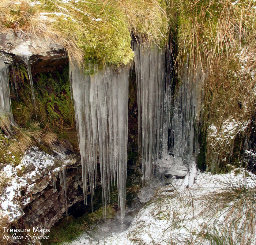 Icicles at the entrance to one of the abandoned Blaen-y-Cwm trials. Having solved, in my head at least, a couple of mysteries, I carried on north, towards Blaen y Cwm. This quarry feels like the poor relation. Cwt-y-Bugail, a little to the north, managed to find the famous slate of the Blaenau back vein, but Blaen-y-Cwm's proximity to the Igneous excesses of the mighty Manod mean that the slate is distorted, metamorphosed and only winnable in small quantities. My photo of the tunnel in the Blaen y Cwm pit makes that quite clear. In a bid to find good rock, the various lessees of the quarry looked far and wide for slate, leaving trials all over the place. The first is a trial that the Tramway passes over (above) soon after starting off from the Manod quarry. Another was above on the hill (actually not on the Blaen-y-Cwm sett!) a fairly extensive trial with a mill. This has been tipped over and obliterated by the modern Manod tips. Another trial emerges to daylight near the top sheave pillar of the Blaen-y-Cwm incline. 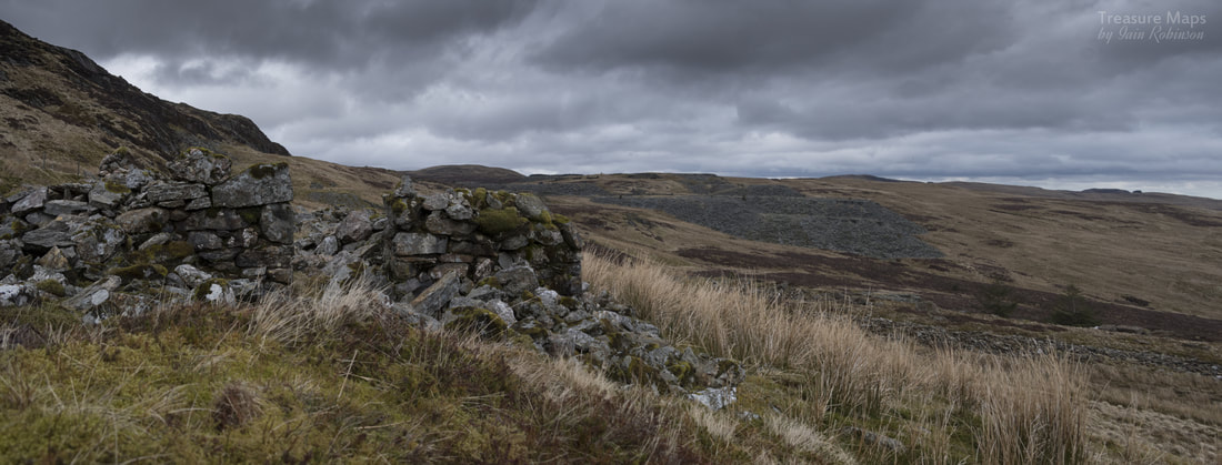 The ruinous barracks, with Cwt-y-Bugail in the distance As you follow the tramway, the barracks block comes into view on the right. Made up of igneous rocks, it has deteriorated to the point where it is hardly recogniseable. The stone is roughly worked and it would seem that not much care was taken with the construction. It was built after 1872, according to the maps of the period, and M. J. T. Lewis* notes that one occupant listed was the caretaker, John Jones yr Hen Blas. From here a good view of the various workings can be had. Below the barracks is a reservoir, now a brackish bog, caused by the building up of an old tip and the diverting of a stream coming off the Manod. I risked getting soaking wet by foraging down from the barracks, as I wanted to try a couple of shots of the hut on the edge of the tip here. It seems to have started life as a weigh-house, but was later converted to a powder magazine. Curiously, it is made from a brown coloured rock that no other structures exhibit, making me think that it is a very early structure from the first diggings of the pit, which was certainly underground at that point. 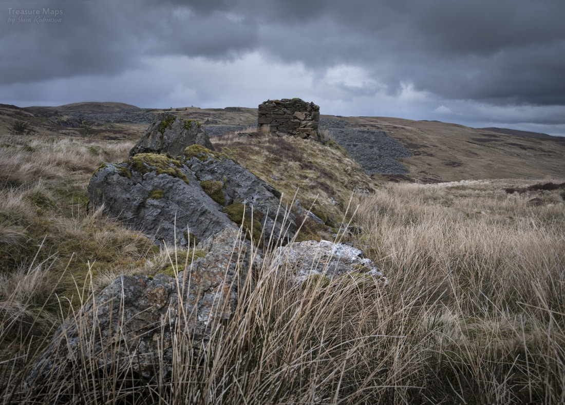 The weigh-hut/powder magazine, showing some of the rock left from the untopping of the twll. Walking from the weigh-hut/powder store is a good way to get a close look into the twll. This was all underground, until one of the managers decided to work the quarry "In the Nantlle manner", that is, as an open pit. This would have been John Roberts, manager between 1879 and 83. The substantial amount of large blocks, formed of igneous rock, indicate that the untopping proceeded from above, the spoil being tipped over the previous underground waste. The pit is a fascinating place, the slate tortured and faulted, much damaged by contact metamorphism. It was said that the production rate from here was worse than 50-1 i.e. fifty tons of waste for one ton of saleable slate! The industry standard was 10-1, which was itself considered hardly acceptable. 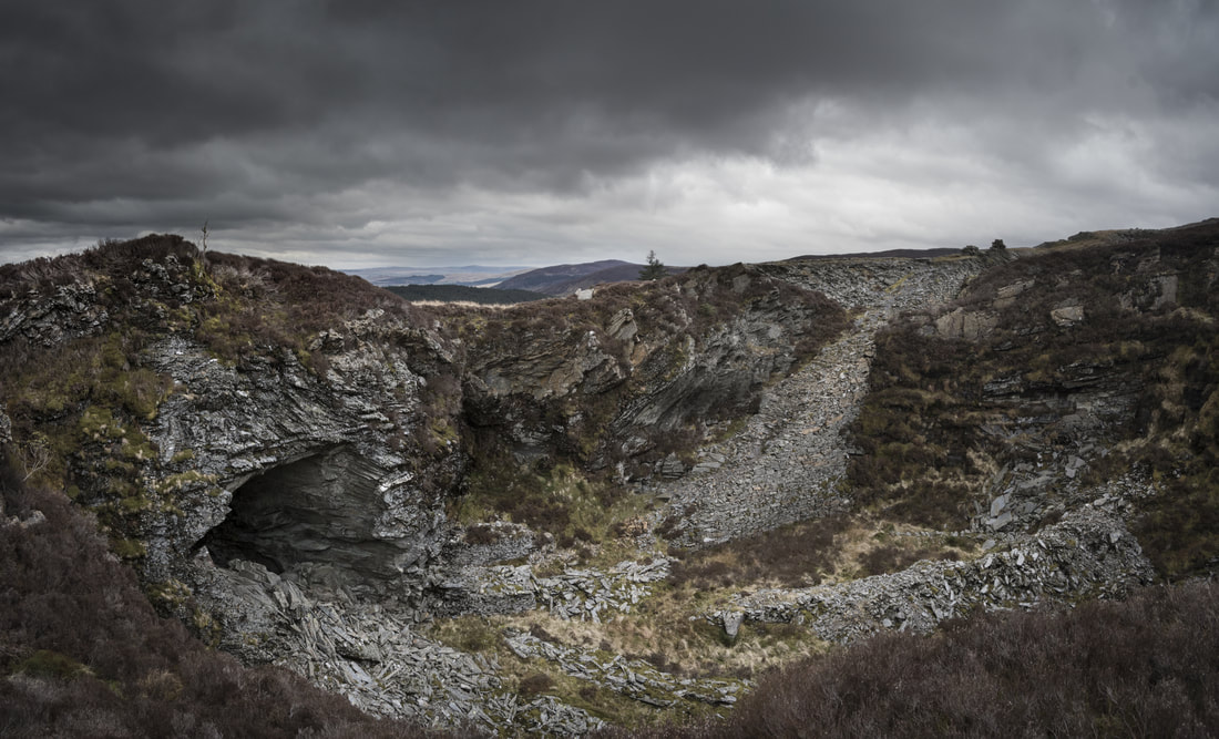 The main pit at Blaen-y-Cwm, named after W. M. Griffith, who developed this underground during his four year tenure as a manager 1872-6. The dry-stone incline was introduced by George Watson, manager in 1898-03. In the ten years since I have been visiting the quarry, I have seen much deterioration as nature inexorably grasps back what was taken. The adit at the bottom of the pit is still passable towards the mill level, but is now deep in water at the mill end. There have been several substantial falls in the last few years as rainfall increases due to global warming. A notable feature of the twll is the massive incline, built dry stone and coming from the south east edge. This was built by George Watson in 1898-03, it's purpose to transport slate from the original Fridd workings, down into the twll and then on to the mill through the tunnel I have already described. 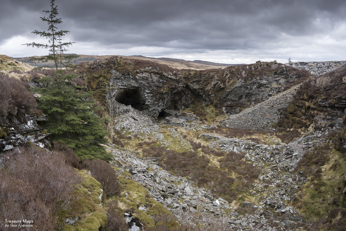 This view shows the tunnel to the right of the vast opening. This tunnel is the one that leads to the mill. I am standing here at the point where a roofing shaft from the original underground working reached the surface. This might be a good point to pause and wait for the next installment of the story, with the mills, the No.4 adit, the incline and the tips still to explore. The scene today is rather chaotic because of the different managers, companies and organisations who all tried without much success, to win slate from this area. It seems that during the time that Gatty was manager, two men, David Williams and Robert Griffith, made some good returns from the old Fridd twll, the one called "Gatty's". This would have been at the time when slate was being pulled out under the Rhiwbach tramway and hauled to the mill via the big pit- around 1898. Even so, the workable slate vein was reported to be only three feet thick. Sadly, typical of this location. The last gasp of Gatty's twll was in the 1960s, when George Budski of Llan Ffestiniog worked the place over with a bulldozer and took some rustic slate for fireplace surrounds. Next time: the mills and adits of Blaen-y-Cwm. Some handy sources of information There are some books out there that mention the area, and one which deals specifically with it. They are all out of print, but it might be possible to purchase them from Ebay or Amazon occasionally. The definitive work is by M. J. T. Lewis, "Blaen y Cwm and Cwt-y-Bugail Slate Quarries," (Adit Publications, 2003.) Alun John Richards' "Gazetteer of Slate Quarrying in Wales", (Llygad Gwalch, 2007) has some very useful background information. Dave Sallery's Welsh Slate web site has a very useful section on the Rhiwbach Tramway, here. A post on my Blogger site about the Rhiwbach Engine House Incline, which I suggest may be constructed partly with waste from Fridd: The Rhiwbach Railway Incline My previous blog has a couple of posts which refer to the quarries here
4 Comments
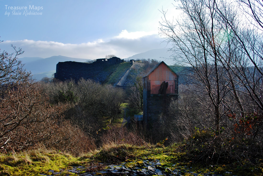 In a little known corner of North West Wales lies a beautiful disused quarry, full of ruins and artefacts from a lost industrial age. For years, folk have come from far and wide, to enjoy the atmospheric vestiges of mill and plas under the shadow of the Nantlle Ridge. Imagining the ghosts that inhabit the cuttings and pits, the old inclines and pyramids, still holding against the weather and against progress. A bastion and a refuge, a place haunted by the memories of those who worked there. A monument. Locals, of course, know what they have got and are passionate about the place. They walk their dogs there every day and will tell you proudly about their connections. Connections, such as within the ruined houses of the lost village, Talysarn Uchaf, each with it's own fascinating story. The chapel at the Plas, like a handshake from the past. The old mill, with the ghosts of the quarrymen flitting through the birches. So many stories and resonances to people still alive whose grandads and great granddads worked there. The lovely stories of Prince and Corwen, quarry horses who pulled trains of slate from the quarry to Talysarn. The late Gwynfor Pierce Jones, celebrated local historian, gave guided talks to parties of fascinated folk, talking about his own connection with the place and it's stories. It's a little piece of post industrial paradise, full of bird song and wildlife. But we who love the quarry have always been uneasy, knowing that this fragile state of affairs can't continue forever. Recently, press coverage of some teenagers, indulging in the craze of "Tombstoning" (free diving into water filled quarry pits) has finally nudged the sleeping bear of Dorothea Lakes, the company that "own" the quarry, into life. Fences are being erected, huge gates are to be placed across the road, signs are going up and access is to be restricted. In one stroke, Dorothea Lakes have diminished the place. The quarry pit is also used by divers, some of whom have lost their lives in the black, unfathomable depths of the main sinc. At the moment it is not clear whether these folk are also to be excluded. It is my understanding that the only structure at the quarry that excites the interest of Cadw and the Council is the 17th century farmhouse at Pen y Bryn. There has been a silence over the priceless and historically important Holman Pumping House, a landmark structure and one that is significantly, miraculously, intact. The pyramids, vast monolithic structures with tunnels through them are either to be made safe after getting a red card from the H&S -or demolished. I wonder if the latter is more cost-effective for Dorothea Lakes. There have been folk seen wandering around Dorothea with hi-vis vests on for a few months now, and the owners have been conspicuous in the company of a well-known Industrial Archaeologist, supposedly putting together a plan for the "World Heritage Site" bid. There are rumours of as-yet undisclosed plans to redevelop the site. A site that, really, should be in the hands of the public. A site that should be cared for and conserved, so that future generations can enjoy it and appreciate the beauty of a post industrial landscape that nature has reclaimed. A site that would be hugely admired and could, I suspect, be made a jewel within this slightly depressed area of North West Wales. Instead, perhaps we will get a bulk landfill site, Or I wonder, a pumped storage Water Power Project, where everyone profits except the tax payer -of course. A few jobs for locals, probably- and a feeding frenzy for construction companies- but at what real cost? A historic site, lost forever under featureless grass landscaping and concrete. Another nail in the coffin for North Wales. The Nantlle ridge may well look on in horror at what is to be done. Gwynfor Pierce Jones would certainly be very disappointed. Stop Press: There has been a new company inaugurated, on the 17th May 2017 - Dorothea Pumped Hydro Ltd, registered in St Asaph. So now we know what may be in store. 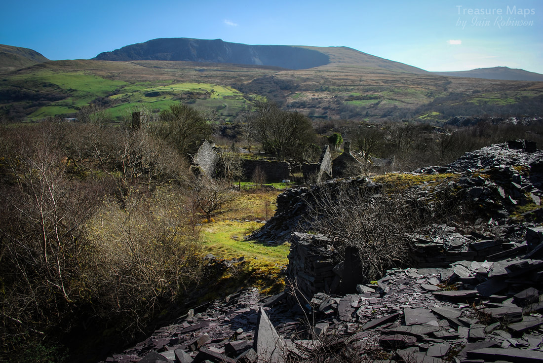 Craig Cwm Silyn from Gallt y Fedw, with the slate mill at Pen y Bryn in the centre. The upper, fascinating reaches of the Dorothea complex. Here are some images from a friend of recent, preparatory works; fencing and notices, the vanguard of the bulldozers. 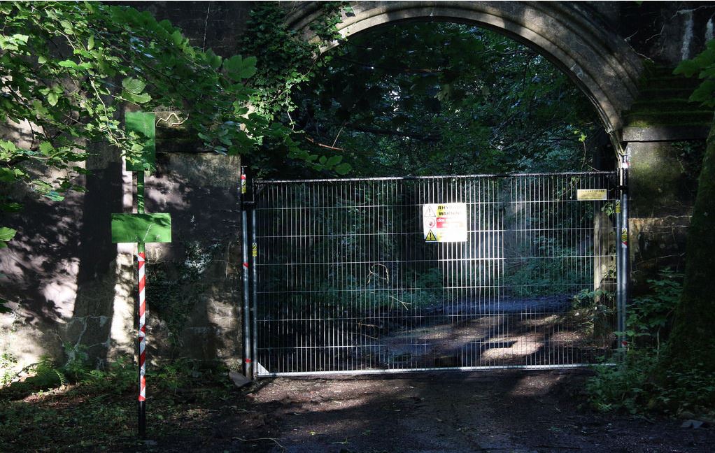 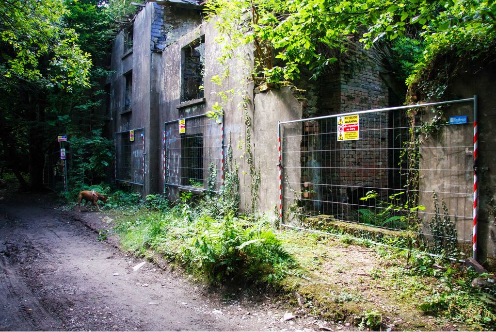 Many thanks to Kerry, aka "GizzieFleury" on Flickr for the photographs of recent developments.
Take a remote quarry and some out-of-the-way farm ruins...add a trackless morass between them, then season with damp weather...  Our first view of Cefn Cam slate quarry. We're only acccidental walkers. We walk in order to get to quarries, or ruins that excite our taste for the picturesque- although sometimes we cover long distances. as a result. But you won't find me scanning the outdoor mags for routes up mountains, or scenic rambles 'twixt hill and dale. Unless there's a mine involved; but then those are usually airbrushed out of the magazines and guides; the unruly relatives that are never invited to the party. So a great deal of thought went into finding a route to this quarry, after Petra spotted it on google Earth. In a seemingly untroublesome stretch of country between the Rhinogs and Ganllwyd, Cefn Cam sat at the top of a very long road with no permissable vehicular access, unless on business- and I don't think mine exploration counts. Now, we've had two visits to this place, the second time we took in some fascinating ruins, so I will give you the round tour in all it's soggy glory. I'm just telling you because for a while on our second visit, the sun shone- in case you wondered why there were a couple of bright photos in a sea of overcast ones.  Trees, trees...a sea of spruce although these have helpfully died off. Coed Cwm Mynach We began our foray at the car park in the idyllic Cwm Mynach reserve at SH68382182. Wales' best kept secret, according to the Woodland Trust web site. We walked up the forestry road for a long way...so long, in fact, that it was necessary to stop for a flask of coffee at the lake- (SH67802391) there's even a bench, dedicated to the memory of a gent who donated a big wedge of cash to preserve the woodland and convert it back to temperate rain forest. For this is the Coed Cwm Mynach, a Woodland Trust scheme, funded entirely by contributions from the public. It was originally owned by someone from the city of London, who sold it to the trust for less than it's market value, in order that it could be returned to a more natural state. Because, of course, up until now, it's been in the hands of the forestry people and is covered with a mix of over-mature Spruce, diseased Lodgepole pine and various other intrusive species. But, thanks to the Woodland Trust, Oak and broadleaved woodland is staging a comeback. The Lodgepoles will be taken out, the other conifers will simply be allowed to die, or be harvested if near a road, and any self-seeded spruces will be hunted down and uprooted. I wish I could be around in thirty years time to see the results. After a long trudge through trees, we came to a junction. Left takes you onto the moor, and was the access road to the quarry. It is also used by guests at the Shooting Lodge, a strangely obtrusive Victorian excrescence, now used as a kind of Hafod. No guns have been on the moor for a long time. There's no wi-fi, no electricity, no mobile signal... and no grouse. I found the structure so ugly that I managed to obscure it with rocks or other features in all my photos, although if you want to know what it looks like, it is featured here. We decided, as the weather was so nice, that we would carry on along the right fork this time, away from the quarry road, to take in some ruins that Petra had spotted on the map, so we walked for another mile and a half. We were still heading for the quarry, but in a kind of pincer movement. The trees became less dense and views opened out now, so you could see the Rhinogiau in all their glory, basking in the distance. We turned left at SH69682452 off the forestry road as it descended into another thick stand of trees, for this was proper forestry and the conifers stood tightly packed for miles. There were warning notices posted here, with surveillance cameras. Reading the Woodland Trust web site, it seems that they have been having problems with bands of two-strokers on their motor bikes, roaring through the woods and churning up the paths- we certainly saw evidence of this. There have been efforts to persuade them not to do so. 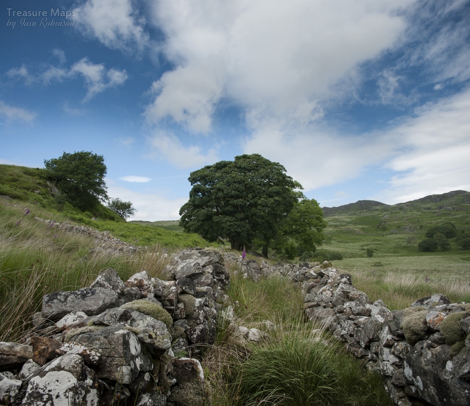 The approach to Glan Llyn y forwyn. Glan-llyn-y-forwyn The path was more like a stream, even in the dryish weather we'd been having, so we changed our boots for waterproof numbers. No, I told you, we're not serious walkers, we just object to ruining our "best" boots... The bracken was high and the path difficult to follow, but we eventually emerged near the first farm, called Glan-llyn-y-forwyn, which translates to something like "the lakeside of the maid". It had obviously been a grand farm with a causeway leading up to it. It commanded a fine view of the Afon Cam surrounded by a gorgeous stand of trees. While there were some mature Sycamores, I was sad to see that some were Ash. 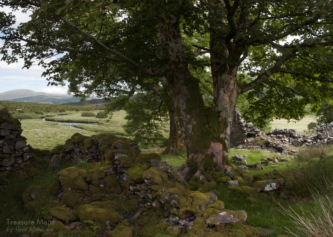 Glan-llyn-y-forwyn farm It was difficult to interpret the ruins here as the deterioration of the farm had been almost complete, so we had our lunch under the trees and admired the views downstream towards Ganllwyd and Moel Cors-y-garnedd. 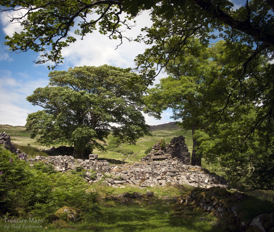 Glan-llyn-y-forwyn farm is at SH69312494 and you can see from the Google view that the surrounding land is boggy, or as the OS puts it, "liable to flooding". We made our way north from the farm, over a modern wooden bridge over the Afon Gam, towards the next ruin. Cefn Cam Farm 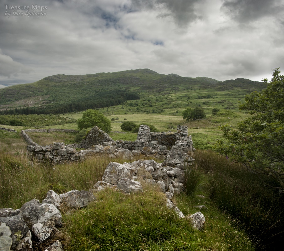 Looking south towards Craig y cae, Y Garn and Garn fach. Glan llyn-y-forwyn is on the tree covered tump in the mid-distance. These were the steadings for Cefn Cam farm, and appeared to be pig sties and a hay/forage barn, although I can't imagine there would have been much of that here. A little more walking took us to the fascinating structure of Cefn Cam itself. It is situated below a low ridge of slatey rock, on a slightly elevated position. 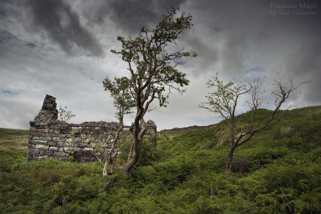 As I was walking around the farm, I noted some very large slates, looking like "Duchesses". I wondered about these, but then was distracted by Petra calling me to look inside. There was a huge old kitchen fireplace with the remains of a range. It must have been a welcoming place, back in the day. No doubt soggy boots were left in front of that range, and wet coats hung up to dry... 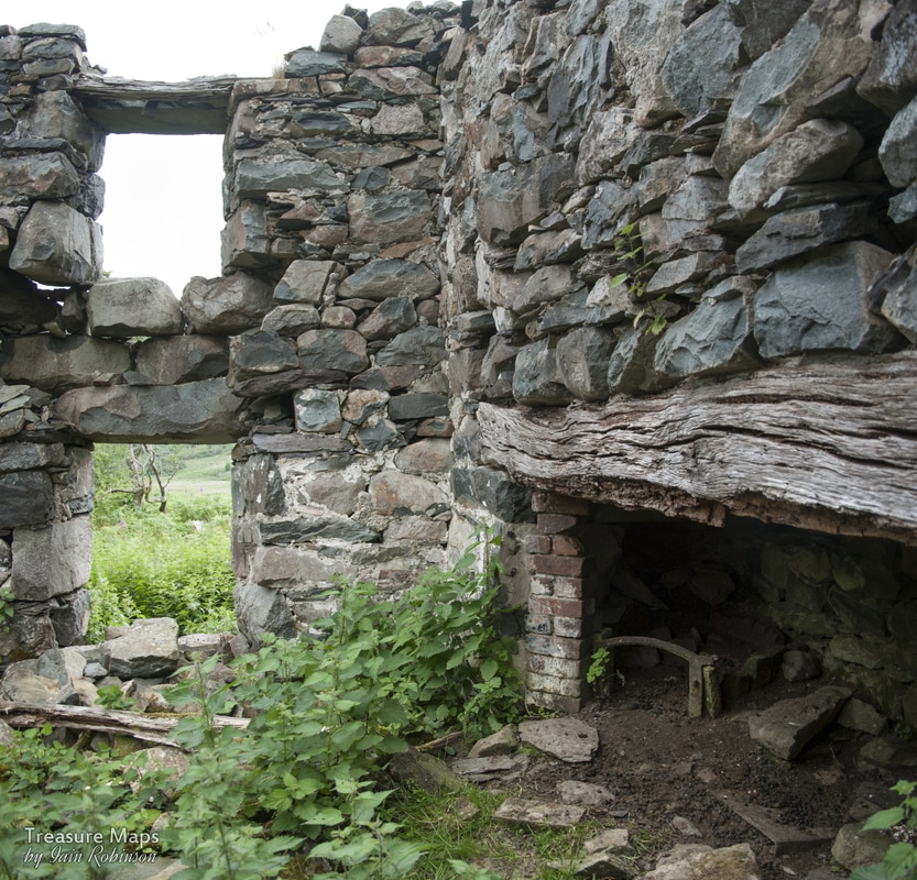 The kitchen range I read a brief note on the internet by a chap whose great grandmother had lived here, having to bring their belongings by cart from Trawsfynydd in 1902- it was a two day journey and I'll bet the way across the moor here was the longest and most awkward. But back to those slates I found. While trying to find an angle on the house that didn't involve too much light or too much sky, I walked up the ridge behind, where an outcrop of fine slate ocurred. I noticed it had been worked, an area twenty feet by ten, beautifully carved out. I'll wager the farmer was a quarryman by day and crowbarred slate out of here for the roof. Dolerite and other rocks outcropped nearby, and judging by the way the stones were worked, I'd hazard a guess that most building materials were found to hand. As if to confirm this, we found a big pile of worked stone near the steading, almost like mining fines, probably chipped off blocks that had gone to build the house. 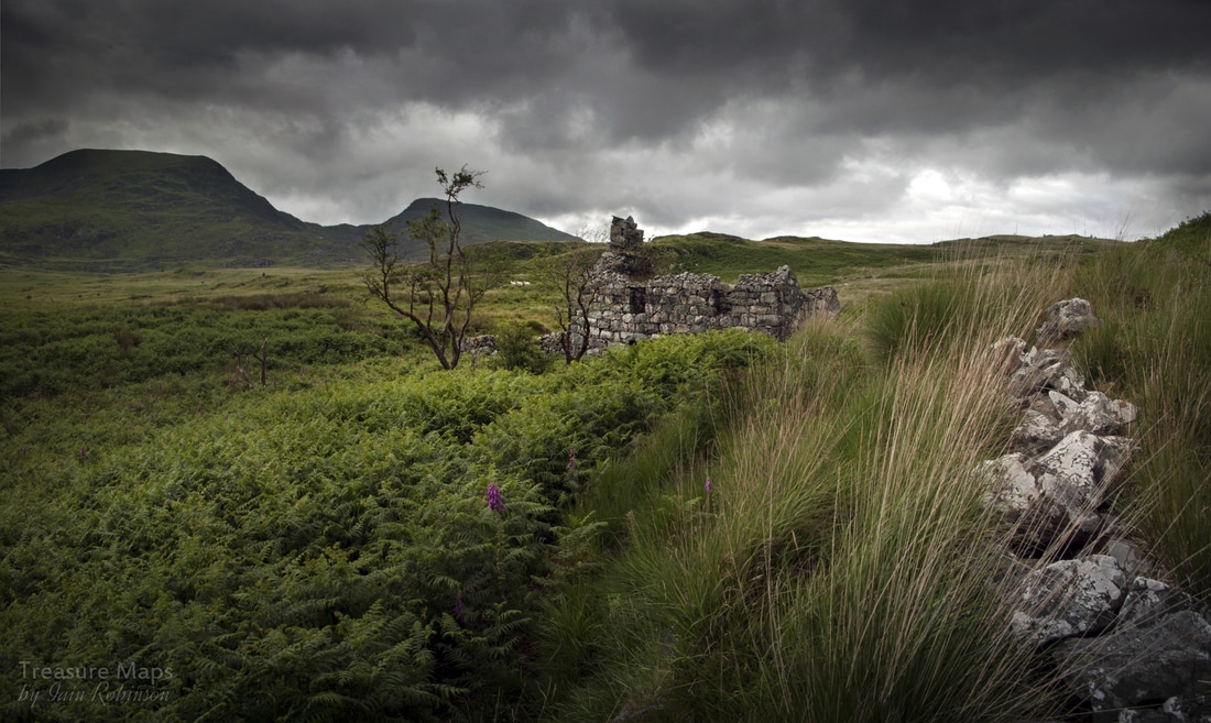 Cefn Cam, looking towards Rhinog fach and Y Llethr. 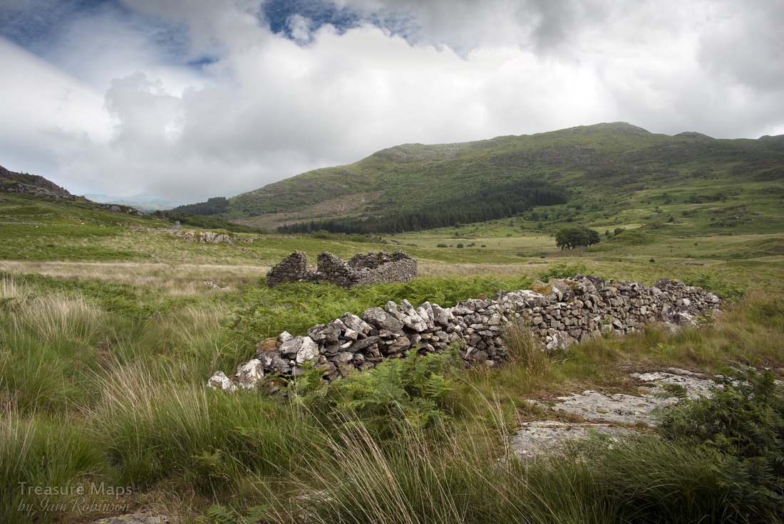 The Field Barn The Morass On all the maps we'd seen, there had been a footpath marked from the farm towards the slate quarry, a couple of miles to the east. The weather was deteriorating, but neither of us could face the thought of battling back towards the road and then crunching up the forestry haul road. It seemed sensible, at the time, to try and find the path. Hindsight is always 20/20, though, isn't it? We made it to a field barn at SH69082537. The terrain wasn't too bad, so we carried on. Gradually, the land became rougher, the grass deeper and more tussocky until it was impossible to make much progress without stumbling, falling in a wet gopher hole, or both. We're both thrawn individuals though, and neither of us wanted to admit defeat. so we bog-bumped on, very slowly. 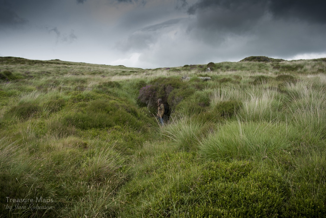 A Trial Adit At least we received some benison from the mining gods, who must have been smirking down on us. Halfway through our soggy oddysey, Petra spotted a tip and an adit, unmarked on the maps and unseen on Google Earth. Probably because we were tired, everything seemed to take so much more effort as we neared the mine. I was so fed up of falling over and then having difficulty getting up, that I crawled for quite a way. Luckily, we both found the situation amusing and at least we had good bearings...I would have hated to have gone round in circles! I don't think that stretch of land has ever been cultivated or sunk to another human boot, and as for the quarryman's track, perhaps that stuck to higher, less waterlogged terrain. The Mine 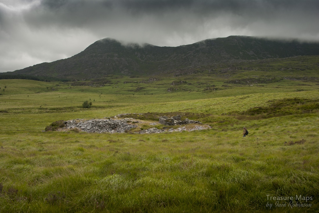 Petra nears the lower adit of the quarry...still a few yards of torture to go... We sat for a while on the wall of the small mill near the adit, vowing to never do something like that again. The only thing that could have made headway over that primordial prairie would have been an elephant, or a monster truck with huge tyres. Eventually, interest in our surroundings returned, after some helpings of Petra's famous home-made flapjacks. The girl strolled stiffly to the adit, turning to me and giving a thumbs down. The entrance was very wet and knee deep in slime. There are conflicting reports about this adit. Richards reckons that it was an attempt to take slate out from the lowest pit and avoid uphaulage, and that a mill relocation to this spot was considered- but the adit was never finished. On a previous visit, we met the landowner, a pleasant and urbane gent, who knew a lot about the place. He reckoned that the adit did indeed go through to the lower pit and slate was hauled out that way. The tips tell the story. Some are composed of large blocks of dolerite, then, one tip becomes rough slabs of low grade slate. On the western side of the hand of tips, two fingers are composed of splitting waste and fines. To my mind, the landowner is right.  The adit...only one way to find out- another day, perhaps... A look at the rest of the quarry seemed a reasonable idea, although the weather had really begun to close in. There was little light about, but I have come to the conclusion that the weather here is always like this. Every time we drive to Dolgellau from Ffestiniog, we gaze over and the southern Rhinogs are looking in a bad mood, even though the sun is shining on us. There are some intriguing ruins here, and I must confess that I had a great deal of difficulty working out what they were. I will start with the things I know...the manager's house, ruinous, but still surrounded by a marked off garden that his wife had happily worked on and grown flowers in. Best of all, it had a most wondrous larder, half underground, looking at first sight like a hobbit-hole... 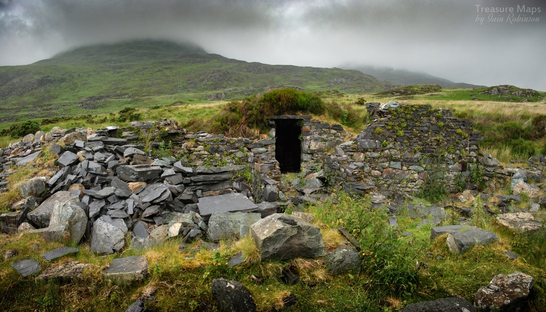 The larder, with Y Llethr behind. What a place to live! There were some other structures that we spent some time wondering about. I think this must have been the barracks... 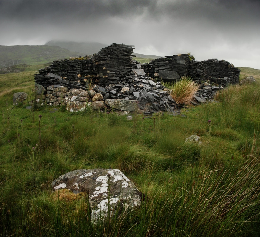 The ruinous barracks block While other structures could be the workshops, near the pit... 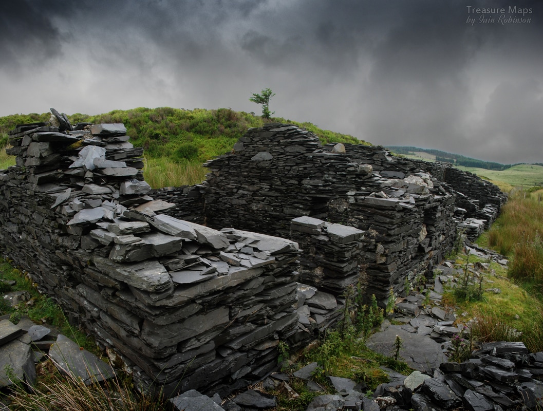 The workshops The pit itself was on three separate levels, with the lowest pit (opening out to the mill) having another, much lower level, which I presume connected with the lower adit. 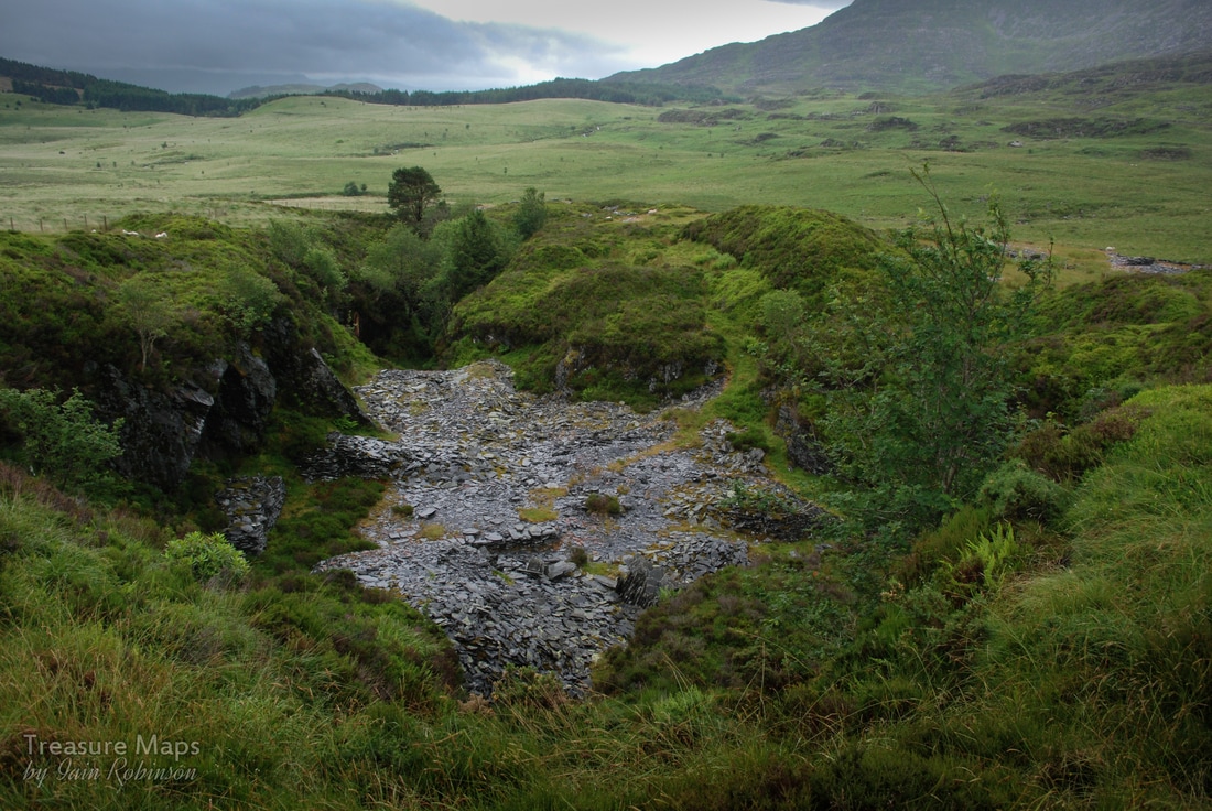 The top pit. The walliau in the pit are from the last working in the quarry, circa 1940's.  Looking out to the mill from the opencut into the lowest pit. The mill was water-powered, presumably a supply was taken further upstream from the tributary of the Afon Gam that runs through the site. A slot in the mill wall seems to indicate that slate was hauled out of the top pit by water power. 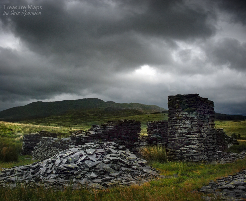 The mill with launder pillar. There are large piles of waste by the mill, indicating that much work was done here. There are no figures for production, and dates suggest a working period between 1840 to 1893, although we know that there was a revival in operation in the early C20th. The slate seems excellent and the landowner told us that the produce was very good quality slate, but that the access road passed over so many different parcels of land, each demanding wayleaves, that it was difficult to make the slate profitable. It being June, there was a profusion of blooms on the moor. That old quarry favourite, Stonecrop was in evidence, along with Lady's Bedstraw, and most surprisingly, quite a few Foxgloves. Petra noted the dainty yellow stars of the Bog Asphodel. In the air, Hen Harriers were spotted on both our visits, (no gamekeepers to persecute them) while even in the rain, larks could be heard singing. 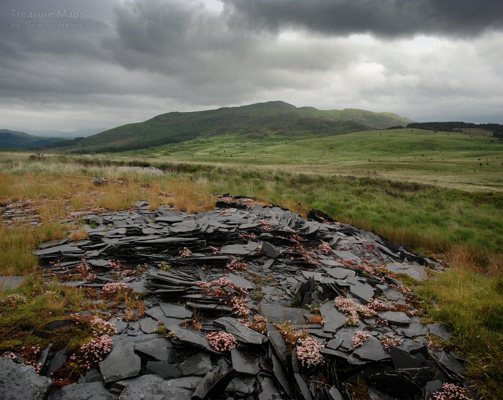 Stonecrop on the tips. The long walk back Unsurprisingly, the rain started to become heavy, so we scrabbled in rucksacs for our waterproofs and trudged down the access road, past the shooting lodge, over a very old bridge and back into the forest.
We hadn't been walking long before there was a loud roaring ...not a troll, but a cohort of two-strokers- dirt bikers, covered in mud. There were over twenty of them, in a rolling sound envelope, stinking the woods out. I was disturbed by how silent the woods became for quite a while after the passage of the loud ones. They're not coming for the scenery, or the wildlife, that's for sure. And now, combing the maps, I see that there's the Diffwys Manganese mine up on the hill, overlooking the moor, so it seems we'll be back again soon - once the memory of that primordial bog fades... A new look at an old friend, at the top of a favourite Cwm ... 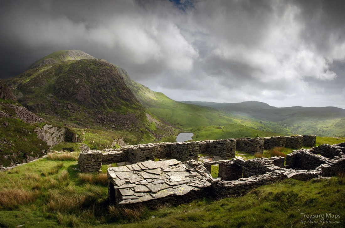 The walliau and barracks block on one of the upper levels at the Prince of Wales quarry. We've visited Cwm Pennant countless times over the last seven years. Almost every time, I have gazed up at the Prince of Wales quarry with a guilty feeling, knowing that I have failed to do it justice. Perhaps due to dull weather, excessively bright weather, or more likely, a lack of photographic ability. The place has an epic quality about it- in contrast to it's distinctly uninspiring economic performance - and I felt I hadn't yet conveyed that. The quarry has an exquisite location at the head of one of Wales' most beautiful and haunting cwms, where poets, harpists, bonesetters, surgeons and preachers once lived; a landscape where every field corner is still thick with ghosts. Now the cwm is largely given over to silence...to holiday cottages and a few down at heel farms. But a lot of magic and mystery remains, and I hope to at least hint at some of it here. 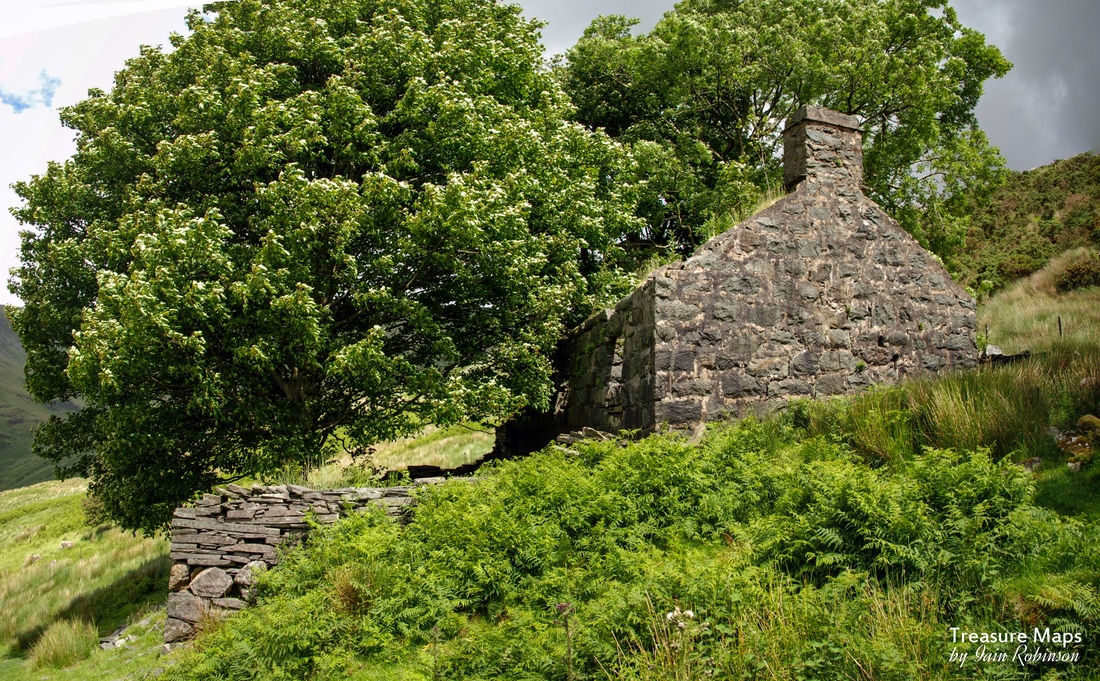 The Manager's House, "Cwm Trwsgl" Perhaps the best way to start out on our adventure is from the car park after Beudy Newydd farm at SH5401849207. You cross a stile and on to the footpath here, noting that the path and car park have been provided with a grant from the EEC and that, as the sign says, you are on Private Land. Only here on sufferance, in other words. A short climb takes you up to the Prince of Wales quarry manager's house, "Cwm Trwsgl". Its a lovely spot, with two mature trees shading the front area. 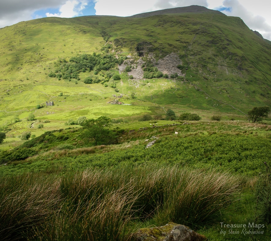 Across the valley is the Chwarel Dol Ifan Gethin, or Dolgarth, looking from this distance like a diagram of a slate quarry - although in fact it was also a metal mine. (Note to self- must explore soon) The house and route up to here have been covered in another blog post about the Cwm Dwyfor mine, so I'll not tarry here. 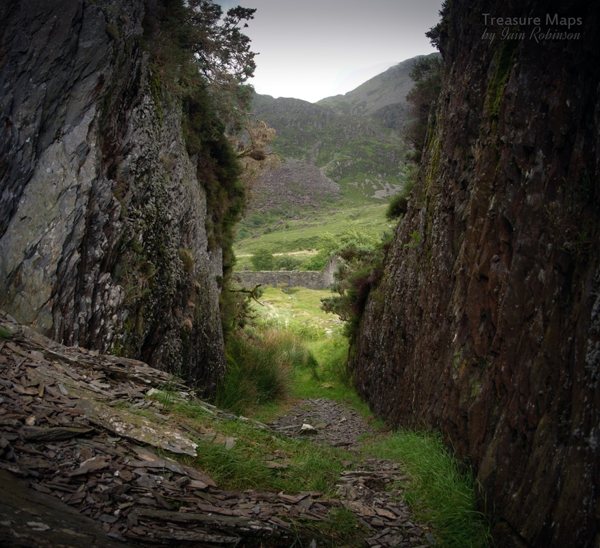 We gained the tramway formation above the manager's house and turned right, south east, to the mill. You have to negotiate a collapsed cutting where the slate is seriously rustic and gives way all too readily- you would think this might have given the promoters pause for thought, eh? 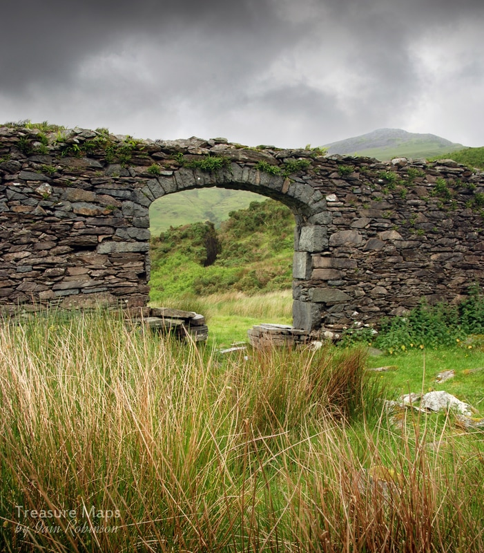 The tramway cutting seen through one of the mill arches. Then, the mill is reached, and what a wonderful structure; not as flamboyant or large as the Pandy Mill in Cwmystradllyn, but fine all the same. I felt in some ways, it echoed the construction at Hafod Las slate mill, Betws y Coed, with almost Brunellian arches to the windows and a monumental wheelpit and leat supports. The wheelpit was deep and hidden in undergrowth, but it is possible to look inside the pit from within the mill. It seems as if it was at least a thirty foot wheel. 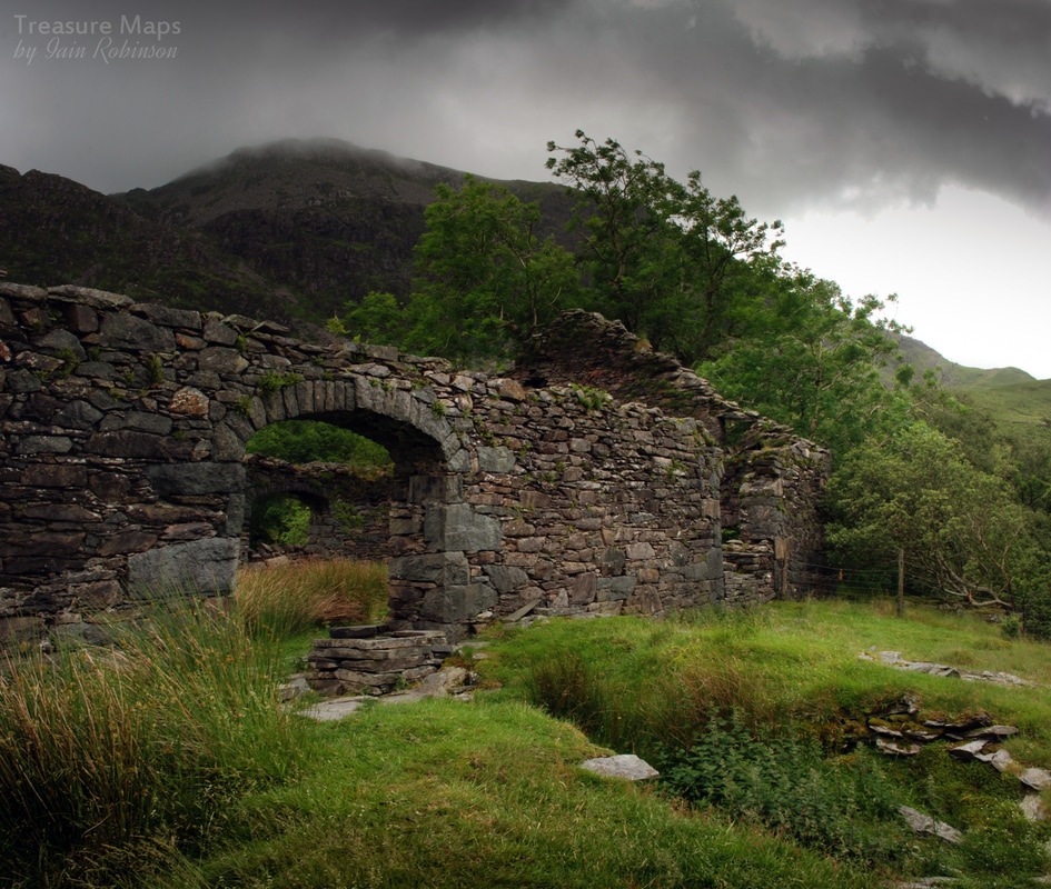 The weather was looking dodgy at this point, with Moel Lefn scraping the bottoms of passing clouds. Today, the mill seems an improbable spot for folk to work. It's very remote and would have been even back in the late 1800s. Perhaps the men lodged at the barracks on the upper levels of the quarry. There was an old Hafod above the reservoir that looks as if it might have provided some accommodation for workers, as well as being a workshop. Commuting on the tramway would be an unlikely choice, given that it was a horse drawn line until latterly- but I suppose we can't rule that out. 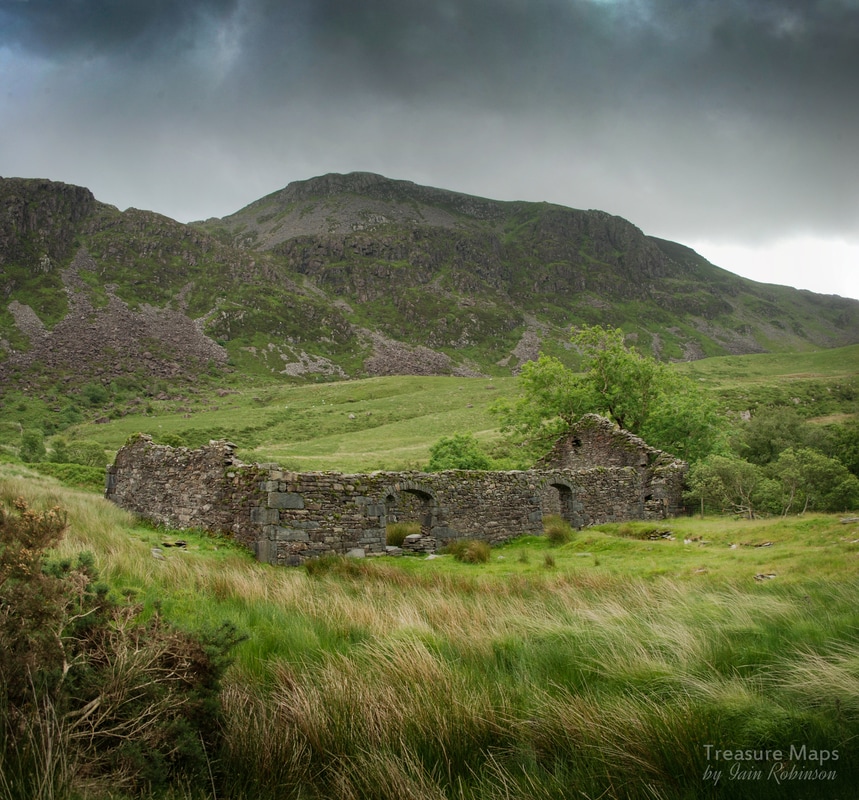 Once we'd had a good look around the mill, we followed the well-worn path up beside the incline towards the main quarry. The incline head here is an impressive feature, made more exciting by tantalising glimpses of what is ahead. 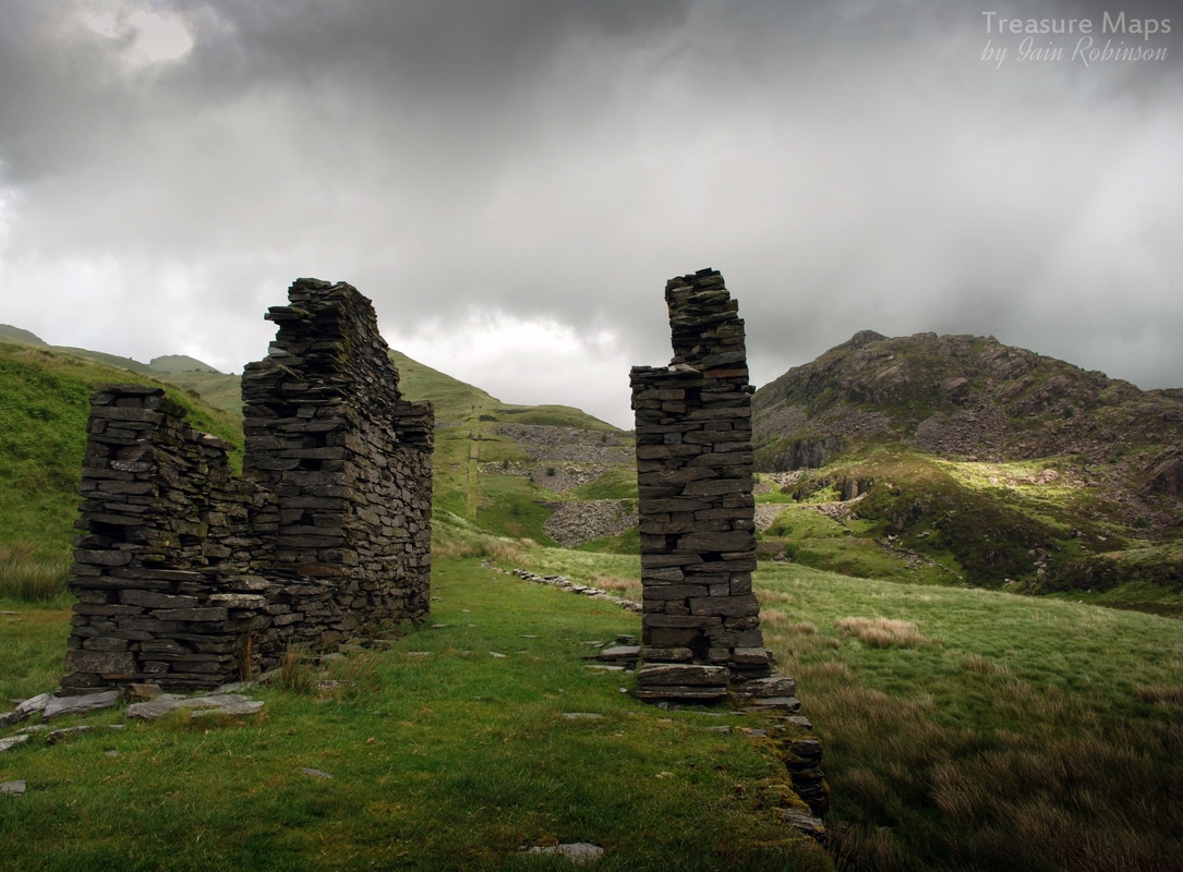 At this point, we decided to explore around the dam area to the right of the photo above, going towards the quarry workshop. We became rather bogged down and had to retreat back to the tramway, deciding to access the workshop from the lower levels, rather than risk wet boots! This was what had tempted us- 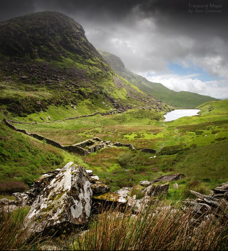 The quarry workshop, seen from one of the lower levels of the quarry. Moel Lefn and Craig Cwm Trwsgl are looming behind. We made our way across and down to the old Hafod, which had been converted into a forge and possibly a barracks. On the way down, the sun came out and we decided to have lunch atop a fine flight of steps... these connected the lowest working level of the quarry with the workshop (and possibly barracks) below. 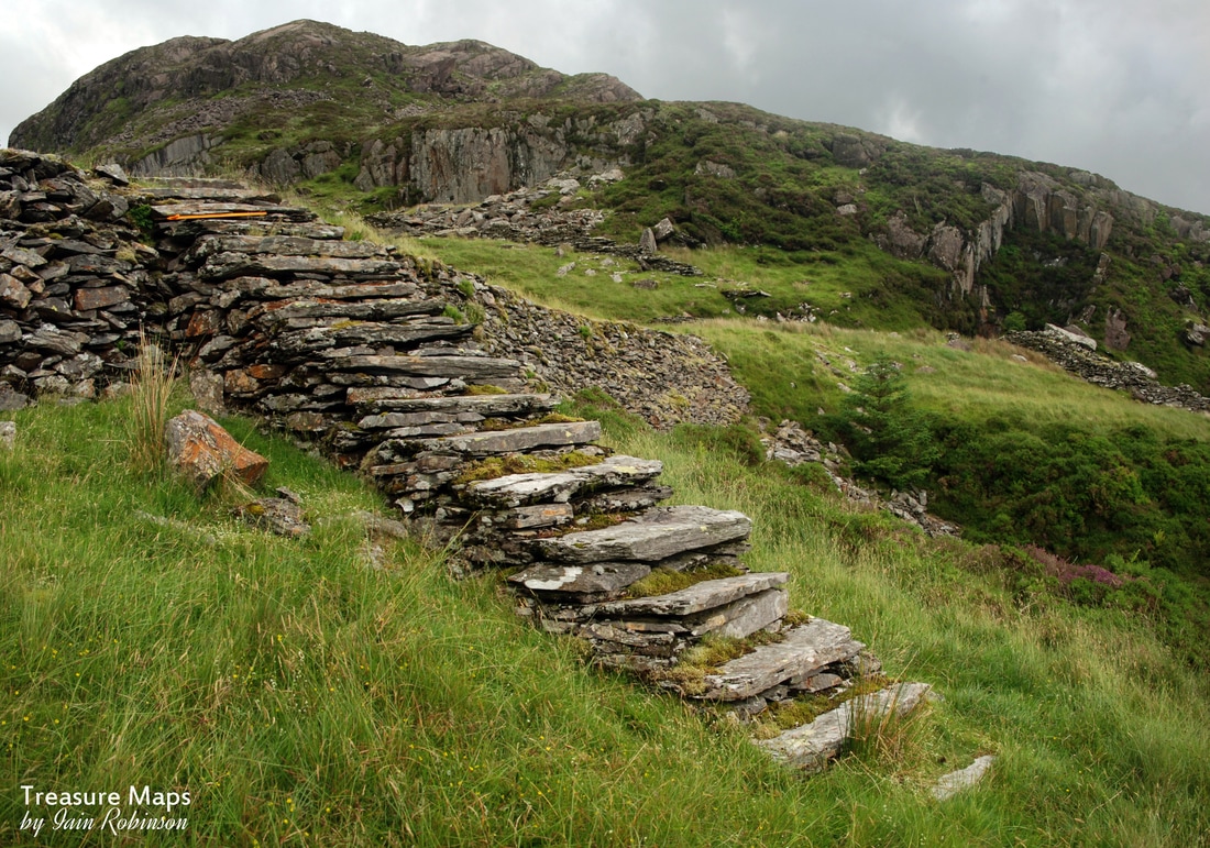 The workshop was an interesting ruin in a very sheltered spot. It showed definite evidence of having been a forge, with the hearth clearly visible at the end of the building. It was at this point that Petra spotted what she thought was a mine on the hillside above. We stored that thought, while we climbed back up for a look at the lower levels. It was our intention to go over and have a look at the Princess quarry before taking time to check out the main quarry again, and we could also take a look at this new discovery of Petra's at the same time. 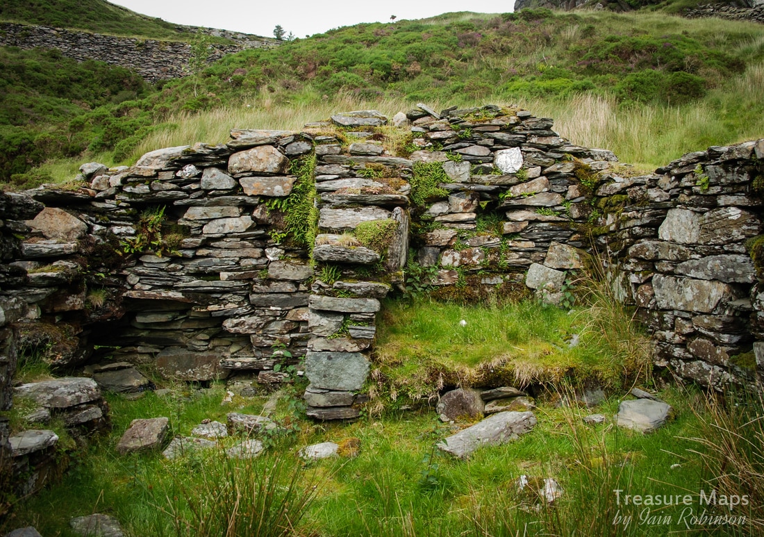 The workshop, showing the remains of a forge. Back up the steps and onto the lower levels revealed an adit, still open but only to those of a gymnastic persuasion. There were colossal slabs left lying about here, a feature of the quarry in general. Slate was processed in walliau around the quarry, but slabs were sent down to the mill. Perhaps a lot of the slabs were found to be just not worth the bother- many were actually used as sleepers for the tramway. Here, I felt there was a strong similarity with the Gorseddau quarry in the next cwm, where huge slabs lying seemingly haphazardly are also a feature. 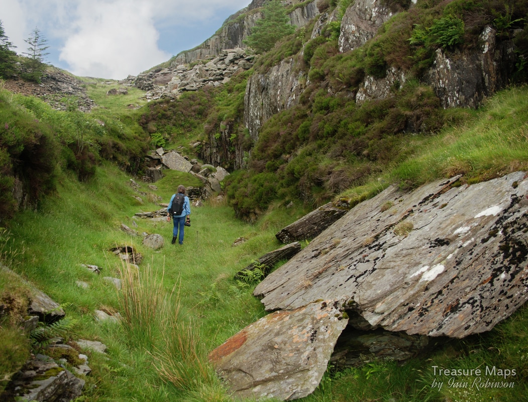 Petra investigates the lower adit and open cut. Now for something that has taken me ages to notice and subsequently study. A feature of most south facing quarries is the variety of lichens and algae that can be found growing on the rock. The most common is the Map Lichen, (rhizocarpon geographicum), so called because it looks like, well, a map! This lichen is also very handy, because we know that it grows at slightly less than 1mm a year- so a (very) rough guess can be made about how long some of the slabs have been lying in position. It is possible to date the lichens accurately by a process called Lichenography- very scientific, of course and a whole different area of scholarship, intended more for the dating of glaciers and moraine deposits..  Some nice examples of Map lichen on this slab by the tramway. The slabs on the floor have been used as sleepers for the tramway. The Prince of Wales quarry is not the best site for lichens, the nearby Gorseddau has some better examples, as does Rhosydd quarry in the Moelwyns, but there are some other notable species here which I will point out as we encounter them. Of course, now I know a little about lichens, I spot them everywhere... At this point I will pause, returning very shortly with the next episode in this study of the quarry...with an exciting bonus feature, a peek at the Princess! There will, of course, also be the customary "Factoids" feature for those hungry for hard data to work their Industrial Archaeology molars on. 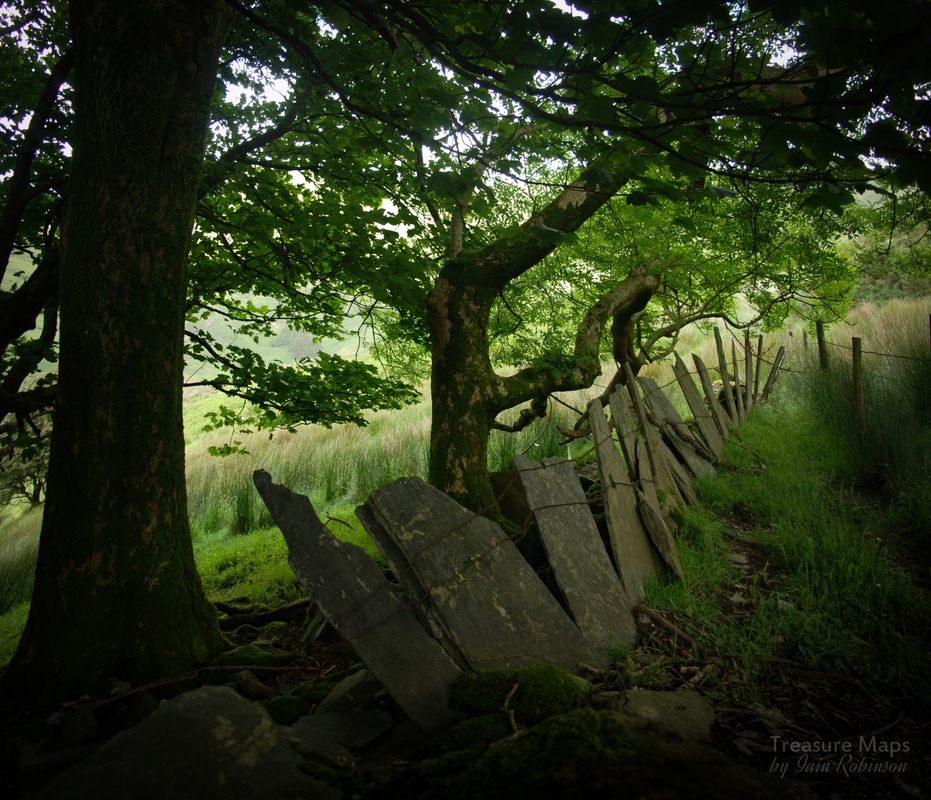 Crawiau Llechi (slate slab fence) at the Managers House. 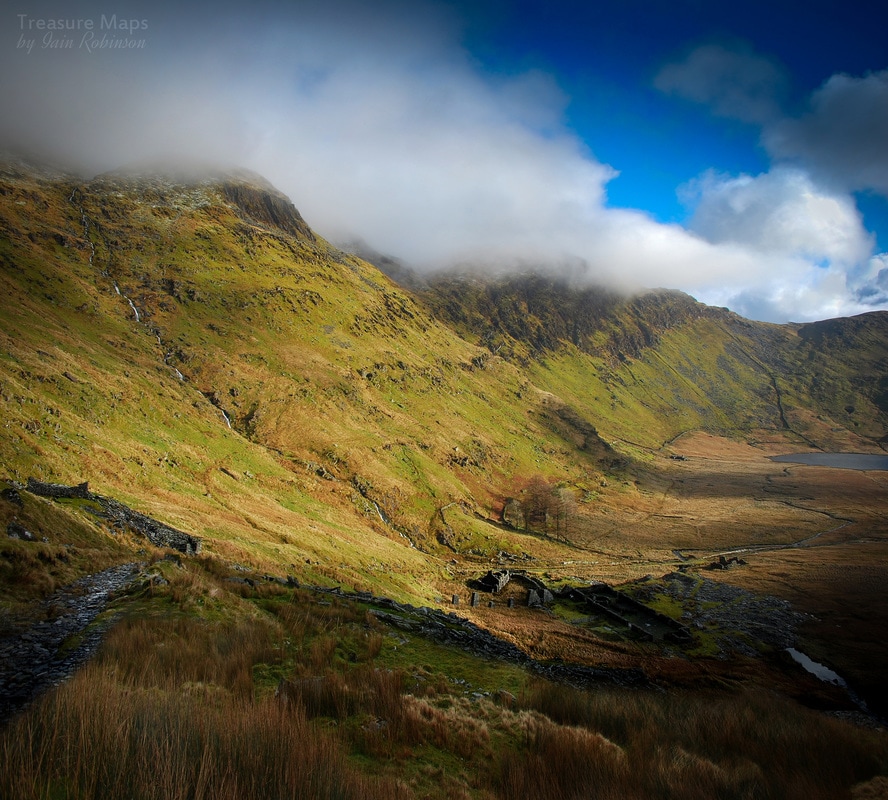 Conglog, seen from the bwlch between Cwmorthin and the Rhosydd plateau. The Conglog mine seems always to have been overshadowed by it's more powerful neighbours. Literally, in the case of the mighty Rhosydd workings to the south west, while Cwmorthin, down the valley, held the door keys to it's route to market, the only economic way out of the cwm. These days, most people hurry by the four strange daylight chambers of the mine on their way to Rhosydd, or to the summit of Moelwyn Mawr. We usually stop to have our lunch near the weigh house on floor C and are often entertained by an endless cavalcade passing by. Walkers fully kitted out, others in flip flops. Two guys walking up bouncing a football. People with dogs. A sweating, galloping army platoon. Parties of children doing outdoor activities. None ever seem to give the place a second glance. 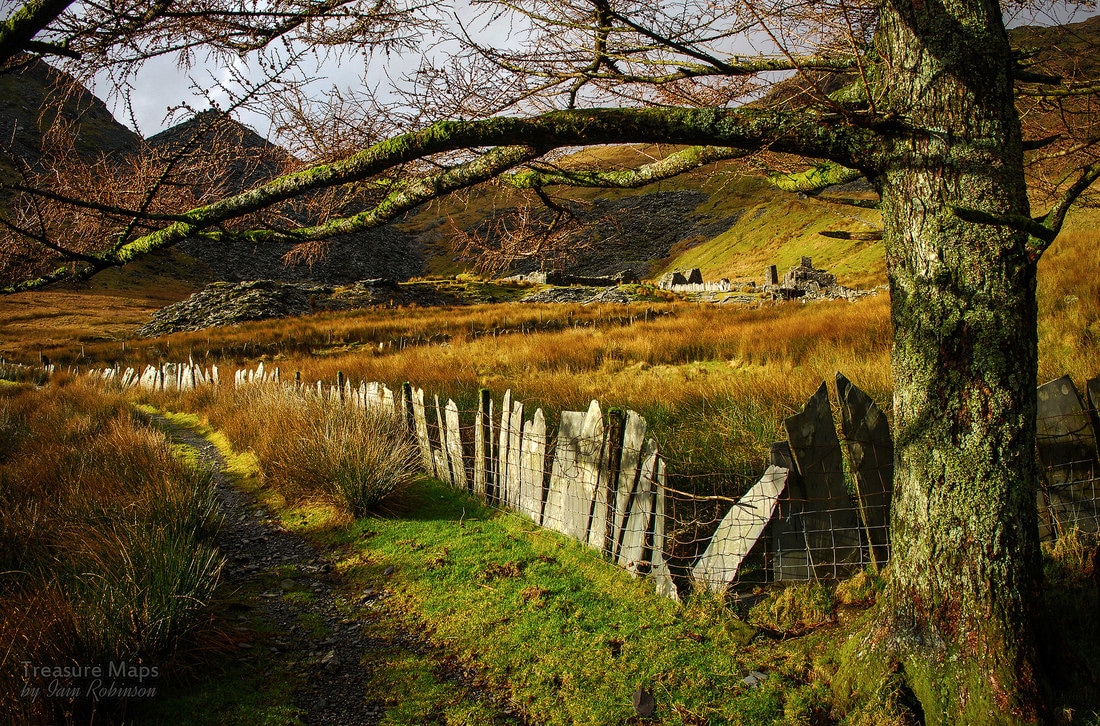 Conglog seen from the Rhosydd Quarry managers house Yet, Conglog is an impressive sight, with rows of ruined buildings, a mill (converted to a sheep pen), the aforementioned twlls in the side of the hill and large slate tips. Not to mention the craziest set of launder pillars. To understand, perhaps we need to go back in time a little. The beginnings The quarry was opened in 1854, when it was the subject of a temporary permission to extract minerals order, or “take note” from Cwmorthin Uchaf farm, belonging to Lord Harlech. One of the partners of the enterprise was Robert Roberts, a surgeon at the Oakeley Quarry hospital at Rhiwbryfdir, and it is assumed that he provided the capital for the venture. By 1868 a 21 year lease had been taken out on the land. Meanwhile, nearby Rhosydd had been extracting slate up the hill since 1853 and their spoil tips and buildings began to encroach on the Conglog sett. They, Rhosydd, had built their manager's house, Plas Cwmorthin, on land to the east of Conglog, just outside the leased territory. But in a later, possibly aggressive move, they built a barracks on Conglog land, next to where the mill would be in 1865/6. From then on, there would be frequent disputes about land . Rhosydd had also built stables near the Conglog mill. From this distance in time, it all looks a little like intimidation. Standing at the launder pillars near the Conglog mill and gazing up at the vast floor 9 tips of Rhosydd there is certainly a feeling of “big brother”. 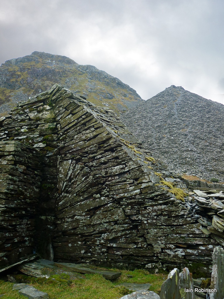 Intimidation? The Rhosydd tips tower over a Conglog launder pillar. And yet...Conglog were to have the last laugh. Cwmorthin had stood in the way of Rhosydd when they had wanted to take their produce down to the Ffestiniog railway. The wayleaves and tonnage charges proposed by Cwmorthin were prohibitive, forcing Rhosydd to build the famous, vertiginous incline down to Cwm Croesor. But when Conglog suggested the building of a tramway down to the railhead at Tan-y-Grisiau in 1873, Cwmorthyn rolled over and let them do it, much to the chagrin of big brother up the hill. Things had changed at Conglog, though. The quarry had gone through several rounds of personnel and that year was managed by a Devon man, W H B Kempe. It is speculated that he was related by marriage to the manager at Cwmorthin, Joseph F Sims, also a Devonian. Perhaps it was a case of blood being thicker than water, who knows? The upshot is that we were left the lovely tramway from the old Cwmorthin mill all the way to Conglog to walk on, bounded by those beautiful slate slab fences. Of course, the bad feeling hadn't ended, there were numerous disputes over water rights for powering the machinery - and Rhosydd built a stables near the Conglog mill. Conglog eventually won the right to use Tan yr Allt, the Rhosydd barracks built next to their mill, but that option was never used. Rhosydd did tip over one of Conglog's water sources, the Bwlch Rhosydd stream; as a result, in 1903, they won the exclusive right to water from Llyn Conglog. I wonder if this is why the mysterious waterwheel pit and bastion at the bwlch was built, but never used by Rhosydd? We will never know. 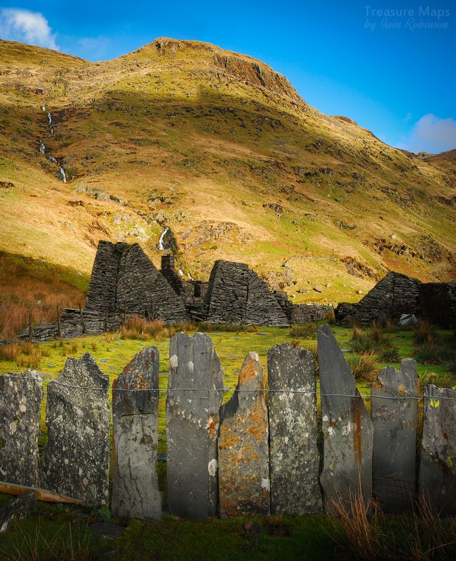 Launder buttresses and "Crawiau Llechi" (slate slabs) Underground While not as spectacular as Rhosydd or Cwmorthin, Conglog does possess some beautiful chambers, cathedral-like in their size and acoustics. Not that I recommend singing in the chambers as there have been some mighty falls, like the dagger-shaped slab of slate that buried itself in the floor of chamber B4. The enormous lump of slate (the size of a single decker bus) at the back of B4 must also have made a bang when it landed. I've been told of men having burst eardrums and broken ribs from being in a chamber when a major collapse happens, and I can believe it. Luckily, nothing fell on the several occasions we were underground. 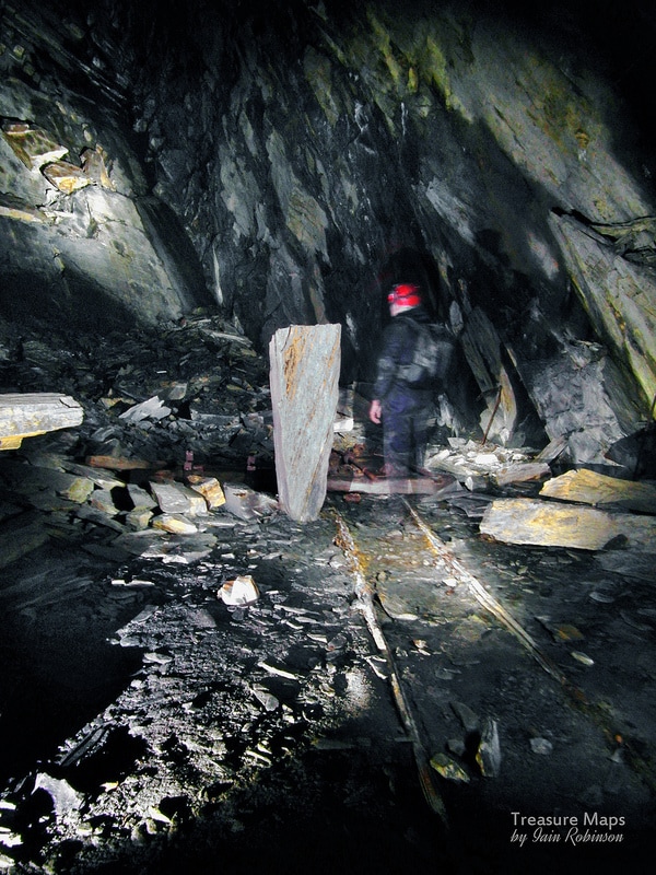 Access to the level B chamber system at Conglog is past a perilous looking collapse, held up by a prop of timber and some dubiously stacked rocks, most too heavy to lift by one man. We squeezed past this with great caution, before entering into the airy space of chamber B4, where the roof rises 30 metres above, feint light coming in from a roofing shaft high at the end. An adit drives further into the hill, expoiting the north vein. The only chamber to work the back vein, the one worked by the Ffestiniog slate quarries such as Maenofferen, is near the adit portal, coming off the level B tunnel before the collapse. A further three chambers lie along the line of the adit, running east-west. The adit then drives 249 metres further into the hill, although why, when the North Vein had obviously been found, I don't understand. 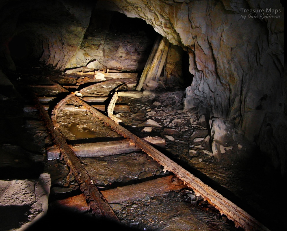 The level B adit, with an entrance to the back vein chamber (B1), the only one to exploit the back vein. As far as we can find out, the level B workings were driven by Devon miners in 1872, under a sub-lease from Robert Roberts, the main quarry lessee and a surgeon in the Oakley Hospital, whose men were busy on level C. The rent charged enabled Roberts to pay his rents from the landowner. Later on, the quarry was worked by a consortium of local men, trading as the Glyn Ffestiniog Slate Company until 1910, when the quarry closed. It seems that B6 was the last chamber to be worked, and rather poignantly, a loaded rubbish wagon sits inside, waiting in vain to be trundled outside and tipped. Surface remains The most obvious features are the launder pillars, leaning because they were built on a foundation of slate waste. They were shored up several times, using the skills on tap from the quarry craftsmen. They seem now like rather fine sculptures, superior to those contrived examples in Blaenau Ffestiniog near the FR station. The incline, cut by the later Rhosydd quarry track, was constructed in the 1870s and is at 30 degrees, becoming shallower as it reaches the mill. The mining Journal in 1874 states that Mill and incline are the work of John Edwards of Ffestiniog, manager between 1874-79. The archaeology of the mill, as I mentioned, has been greatly confused by use as a sheep pen, but we know that it was equipped with a 30 foot diameter waterwheel. A list from the 1891 sale has 2 planing tables, 8 sawing tables, and a dressing machine. There is also a smithy and stockyard. Further up towards the incline head are the remains of a weigh house and a drum house. There does not seem to be a magazine anywhere, which is curious. 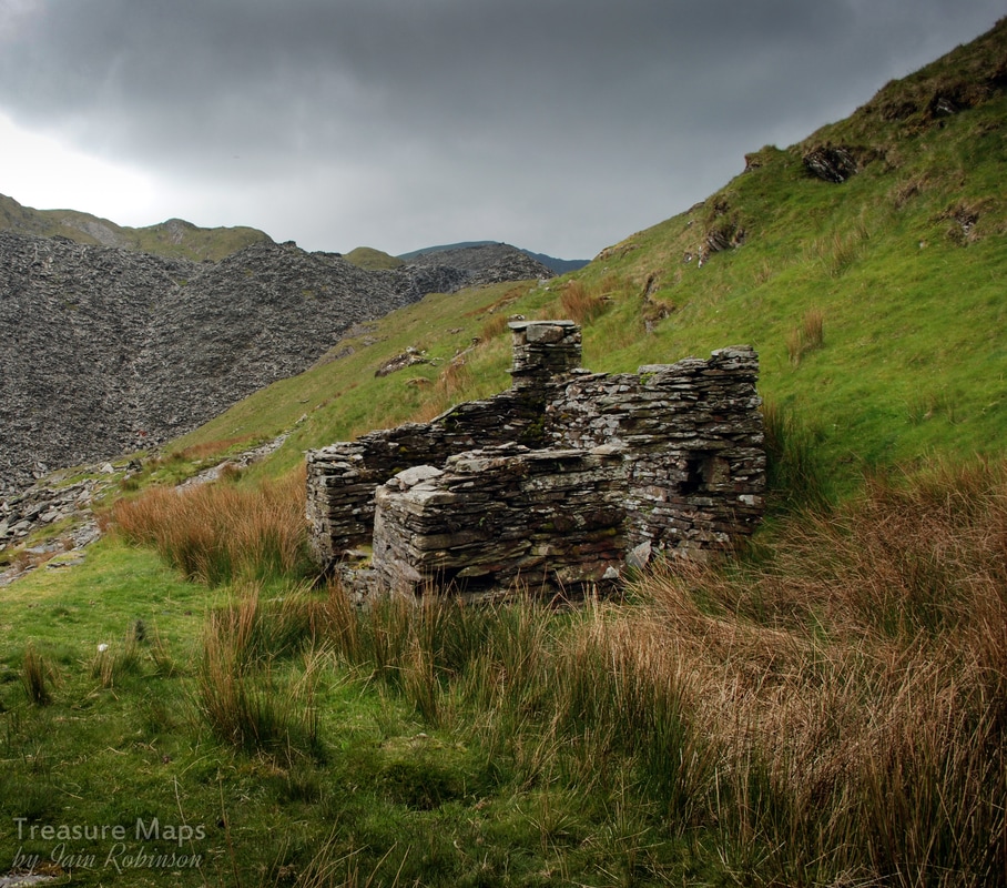 The weigh house at the top of the incline In conclusion, I don't think Conglog is a cinderella. It is as fascinating and intriguing as any other quarry in the cwm and rewards a careful explore, bearing in mind that it is a very dangerous and delicate place. The adits are wet, and SRT will be required for exploration of some of the less obvious nooks and crannies. For further information I can keenly recommend the excellent booklet, "Conglog Slate Quarry" by Celia Hancock and MJT Lewis, 2006, ISBN 0 9522979 4 9 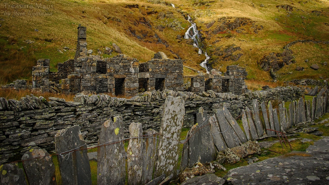 The Rhosydd Barracks seen from outside the Conglog Mill 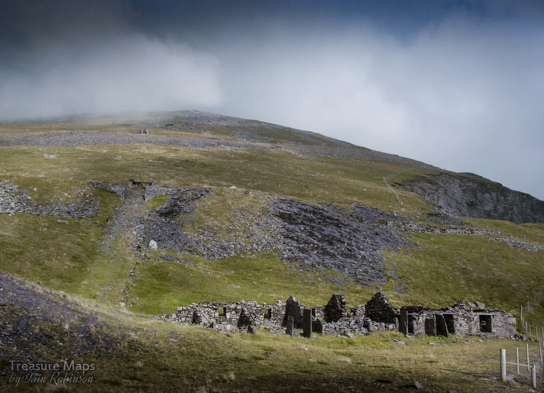 "Barics Aberdaron" with the top levels going up into the sky. This time, we're taking a look at a less visited part of the mighty Dinorwig quarry. Less frequented, perhaps...but in it's own way, very interesting. On a fine day, it has a special character all of its own, despite the top level being cut by the Hydro surge pond road. The best way to take a look at the top levels is to approach by the road, parking at SH 59660 63099. There's space here aplenty- (it is also a good starting point for an assault on the mountains around here). I won't wrap it up, it's a long slog on tarmac to Barics Aberdaron, but a rewarding one. The first sight on the way is the abandoned workings of the Marchlyn quarry, an attempt by the management of the main quarry to find some easier pickings without bad rock and tipping restrictions. But there's no such thing as a free lunch and the new quarry never prospered. It was first opened in the thirties, then a really concerted effort was made in the fifties when things were beginning to look bad for the main Dinorwig quarry. The slate was never good enough and much effort and money was wasted on this desperate scheme. 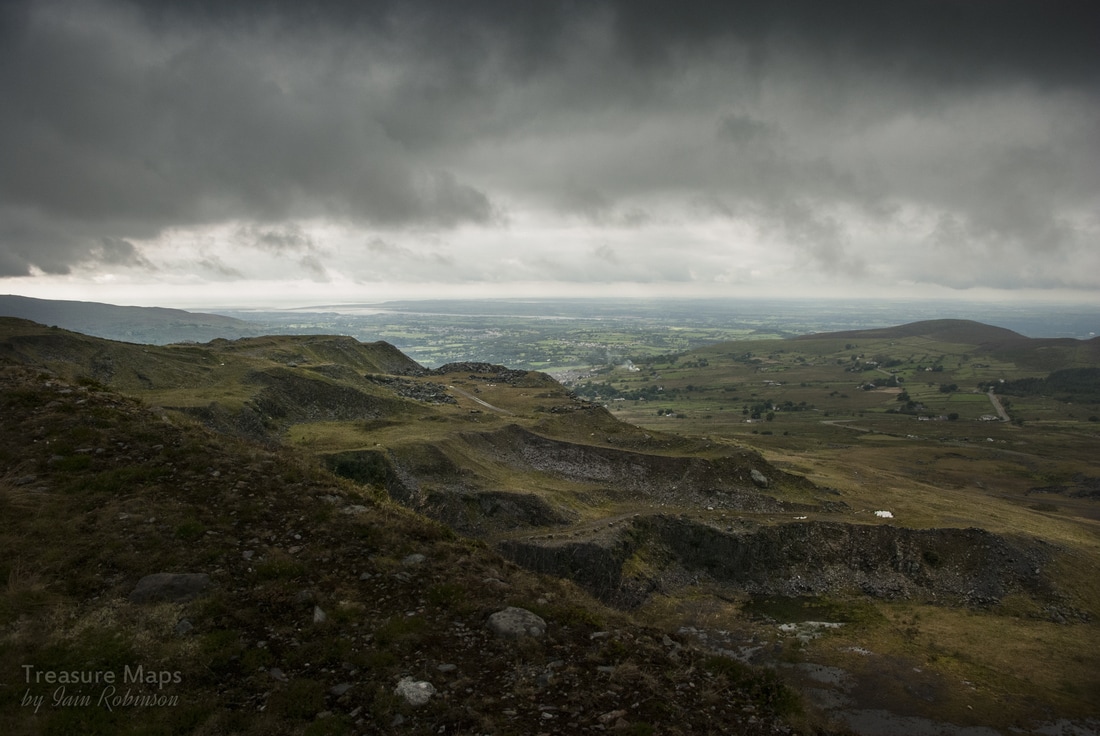 Marchlyn... a chaotic site now, after being used by the hydro company to tip thousands of tons of waste rock from the underground tunnels. There was a proposal to re-open work here and extract rock for raising the height of the Marchlyn dam, but so far, that has not transpired. Walking further up the road the views become more intriguing. Assuming you are lucky to have a fine day, it is possible to see as far as Anglesey, but perhaps of more immediate interest are the two imposing places of worship down in the shallow valley below.  Look closely and you will see a Chapel, then a church with a spire behind it, both lit up with a chance sun beam. Llandinorwig Church and Cefnywaen Chapel, seen from the surge pool road, near Marchlyn. The competition between rival denominations, particularly Anglicans and Non-conformists, was fierce in the slate districts. The Anglican church was the church of the employer and his lackeys, the chapels the realm of the workers and the trade unionists. In an attempt to attract members, the Anglicans built the ornate Llandinorwig church on the outskirts of the village. This, of course, was paid for by Assheton-Smith, the owner of Dinorwig Quarry. The Calvinistic Methodists replied by building Cefnywaen (meaning: ridge of the moor) chapel adjacent to the church, adopting an architectural style which was rather grandiose for a Welsh non-conformist chapel and included a huge rose window above the main doors. (Thanks, as always, to the infinitely knowledgeable Eric Jones for this information.) 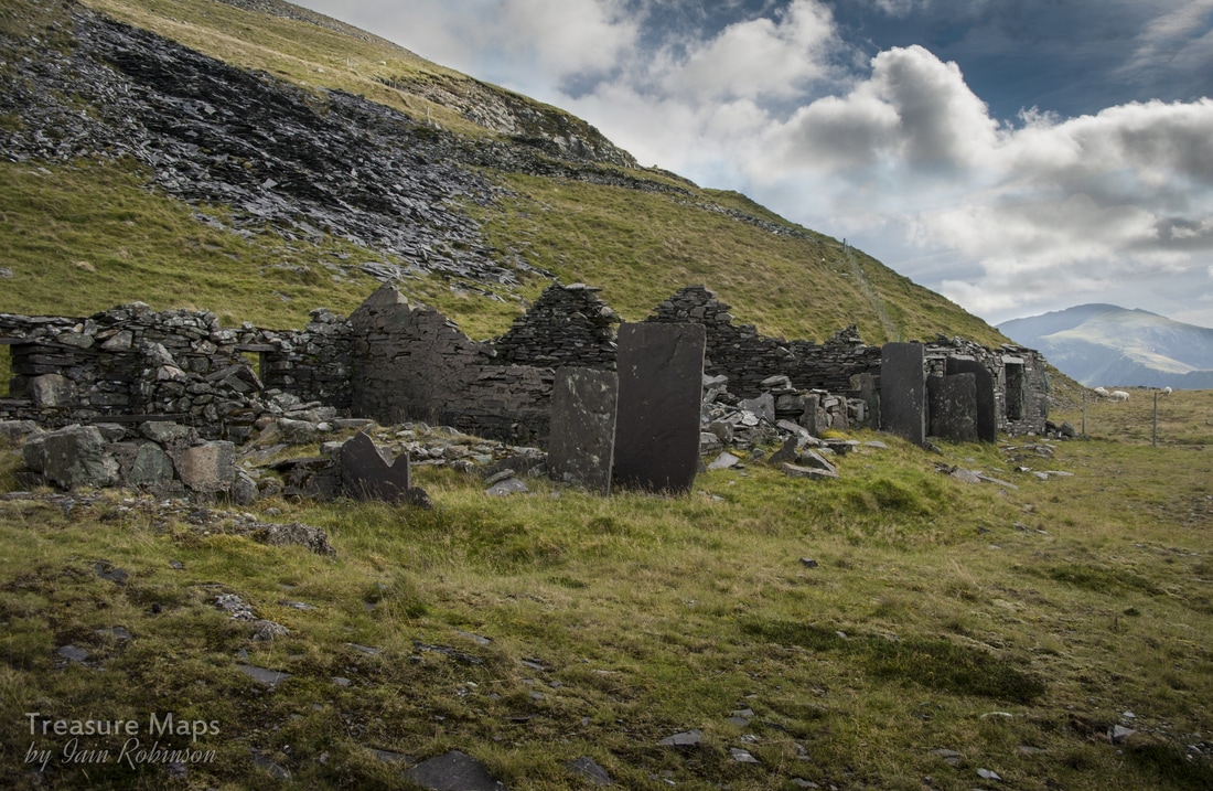 The wind-harried ruins of Barics Aberdaron. The vertical slate slabs are primitive porches to try and keep the draughts out. Finally, the ruined barracks of Aberdaron is reached. There are spectacular views over the Garret district of Dinorwig from here, which is why I recommend leaving the exploration of the top levels until you have quartered the more spectacular remains below. Having satisfied your appetite for the spectacular, you can the more enjoy the subtle delights of these levels. Given the ravages of the weather here at 2,100 feet , there isn't too much of the barracks left. One can only imagine what this place was like in the winter. The place was inhabited from Monday to Friday nights by men from Anglesey. It seems, the more I find out about the quarry, the more it appears that there was a certain antipathy towards the men of Anglesey. In any case, they had to buy their coal for heating from the company, at 2/2d a hundredweight in the 1920's, according to the quarry's accounts book. Not only that, but they had to carry it up from Gilfach Ddu! It's no surprise, then, that it became hard to find men to work here, so in the twenties, the company decided to allow free coal and to provide a free armchair for each man. There was never any water supply, however- I wonder what the company thought the men were going to use- luckily a natural spring was found nearby. The men's basic human rights were ignored, as the company knew that there was precious little local work to be had- and they could pick and choose their workers. Reading some accounts of the quarry, the authors wax lyrical about the Ashetton-Smiths and how fascinating and wonderful they were. Yet they were happy to let these men work for pennies every week without even basic human comforts. Starting from Aberdaron level, there are five levels (or "Poncs" in Welsh) further up the mountain. Above are Langristolius, which at one time, like Aberdaron, went from the Garret side of the quarry to the Braich side. These have been truncated by falls caused by rock deterioration or by the work of the Hydro company. Then there is Asheton-Smith and Enid on the Braich side, topped out by Alice on Garret. The best way up is to climb the shattered remains of the A9 incline (1 in 25) to Llangristolius. This strangely named level was named after the Anglesey parish of that name, and the birthplace of Owen Rowlands, the man charged with developing this gallery. The eastern, or Braich, end of Ponc Llangristiolus is known as Ponc Jubilee. 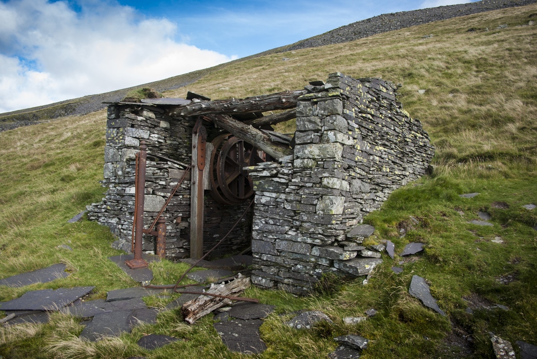 The A9 incline house on Llangristolius is a small and economically built example, with unplaned timbers for the roof supports. It consists of two drums on a common axle. The breaking mechanism is likewise unusual, each drum controlled by curved wooden blocks attached to the ends of timber uprights. One of these is visible in the photograph. Further towards the quarry, the ground becomes dangerous, undermined by rockfalls until finally, the way becomes impassable.. 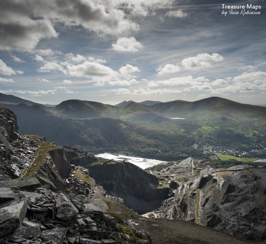 There are some wonderful views of the quarry from here, given a clear day. We explored the level as much as we could and then headed up the hill towards Ponc Alice, the highest gallery at Dinorwig (2,200ft). There was no incline here, just a winch house which is of the horizontal sheave type, very unusual for Dinorwig, but very economical. Slate from Alice and Enid was lowered to Aberdaron in cradles along a ropeway. These higher levels were never very productive and were the last resort before the management decided to open up the Marchlyn workings just over the hill. If only there hadn't been so much indiscriminate tipping in the pits and over good slate measures; but now it was too late, moving the slate waste would be unprofitable. A classic example of the management's mantra - make money now, the future can take care of itself. No doubt there had been much talk in the cabans about the orders given to tip waste over slate reserves! 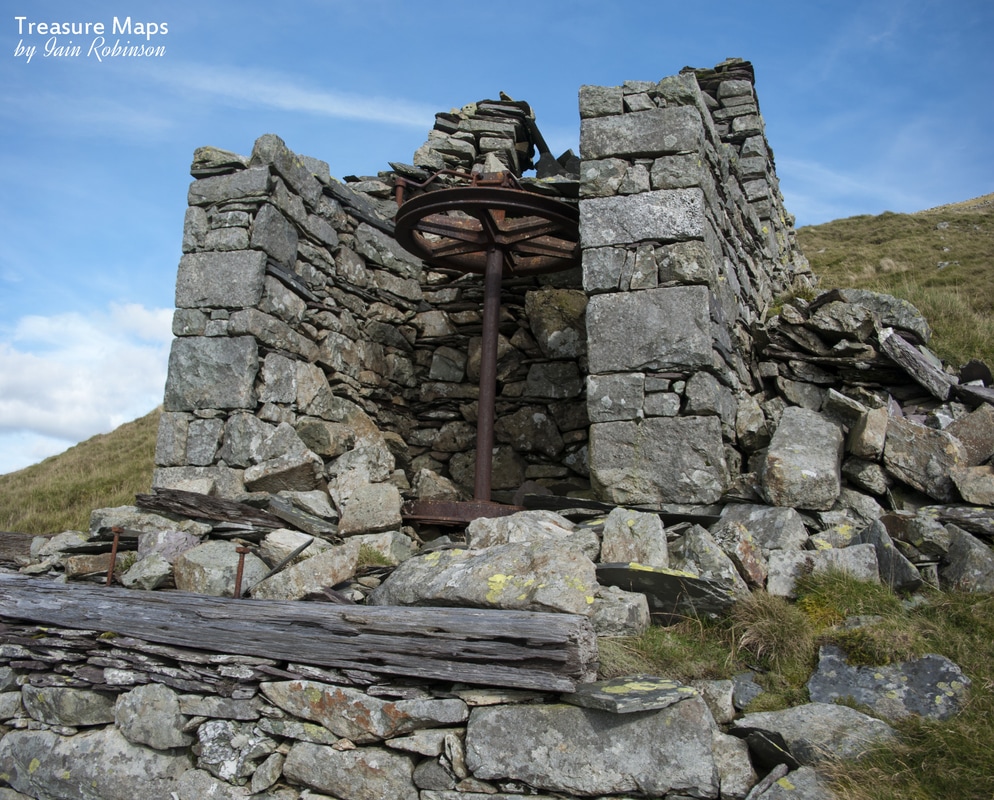 Once we had examined the winch house and gazed out to sea towards Ireland, we sauntered along the level, which had been taken over by the Hydro road. Some of the working face survives; enough to conclude that this wasn't the best Dinorwig product. The surge pool now becomes only too evident at the end of the level. This was built by the Hydro people to compensate for the massive rise in pressure when water from the Marchlyn dam is sent down the pipe to the turbines below. Water levels here can change dramatically and very dangerously, so the pool is fenced off in a rather ugly way. There isn't much to see here anyway, apart from the subtle marks of quarrying in the ground; but at least the Hydro people have provided some steps to access the next level down, which is Assheton-Smith. It won't have escaped the reader that a theme is occurring here with these names...Enid was born in 1888, the daughter of George William Duff and Laura Alice Jones (later to assume "Assheton-Smith" on inheriting the estate) while Assheton-Smith seems a strange vainglory, given the desperate nature of the search for saleable slate reserves. We had now, by walking across the top of the quarry, arrived above the Braich district. It is possible to descend down towards the Australia level from here, should the fancy take you, although it would be a stiff walk back! On this side of the quarry there are some poignant remains, small weigh houses, cabans and blast shelters, lying seemingly forgotten. In one hut, itself almost destroyed by massive blocks of rubble from the making of the surge pool, we found some original core samples. These were presumably from when the level was being prospected. We put them back under some slate for someone else to find. 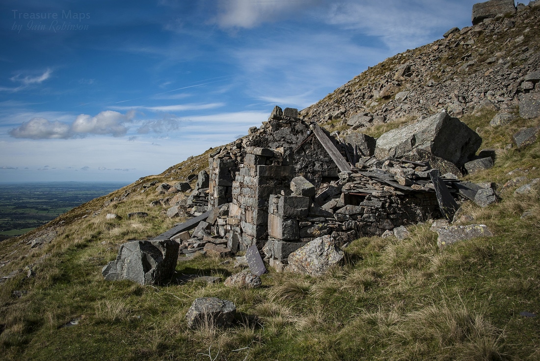  The core samples I find it slightly ironic that history repeats itself here, as the enormous blocks of dolerite from the making of the surge pool were simply rolled over the lip to land indescriminately below, destroying archaeology, sheep and anything else that was unfortunate enough to be in their way. Now it is mooted that stone will have to be quarried for proposals to increase the height of the Marchlyn dam...if these blocks had been stored somewhere more sensible... Finally, we made our way to the massive C10 incline, a dry stone tour de force if ever there was one. This creation is Dinorwig's answer to the pyramids in its sublime lines and construction. It's at a 1 in 3 incline and has a connection to Ponc Aberdaron. Sadly, this incline was never finished and, troubling to relate, there has been a collapse on the top end, so it is no longer advisable to walk on the incline. I still find it hard to credit that each of the stones in the construction of this leviathan have been handled a few times by one, perhaps two men...people now long forgotten. 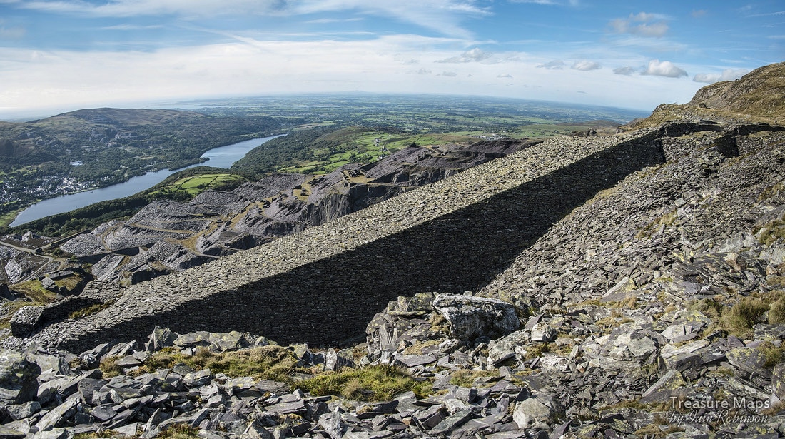 A photo-stitched view of C10, showing the length and size of the incline. 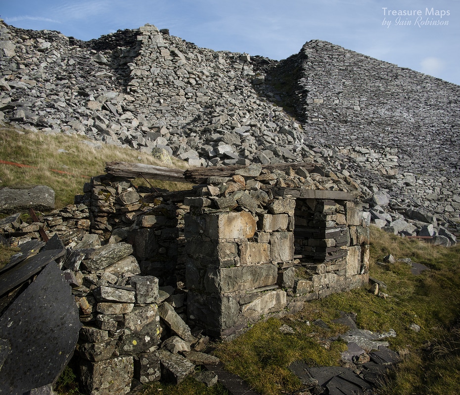 A view of the collapse from Aberdaron. An interesting reflection on the photograph above is that the weigh house was built of country rock, in this case igneous blocks- so it was built before slate was found on the level, whereas the incline was a general construction/transport project and was built from specially shaped slate waste . Both were admirable ways of dealing with waste! This is where the post ends, this time. We trudged back up and over to Aberdaron, then down the road...the fates rewarded us with a wonderful, moody sunset, which made the weary legs feel worthwhile... Grateful thanks to Eric Jones for his always insightful observations and information about Dinorwig. Main printed source for the information here is the book "Delving in Dinorwig" by Douglas Carrington, sadly out of print, but available on Amazon and Ebay. 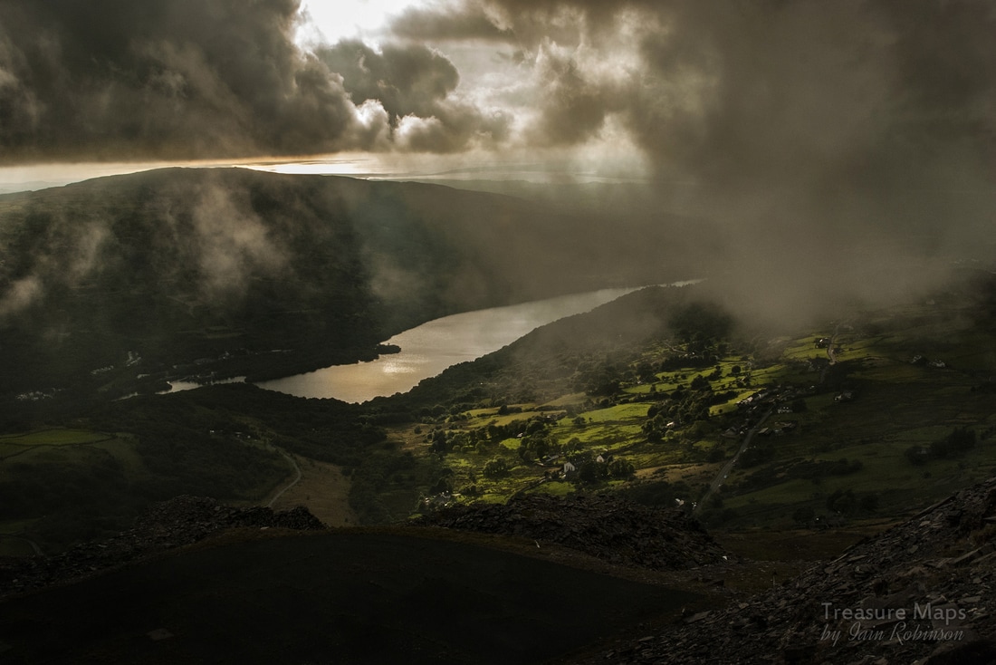 |
TracksReceive the occasional Treasure Maps Newsletter- and alerts when a new post is available!
If you enjoy my content, please buy me a coffee!
Check out my other online activity...
Index
All
|
 RSS Feed